When we head towards the Winter season, the days get shorter and we can expect temperatures to start to fall. Often in New Zealand, Autumn is a very transitional season, swinging from warm tropical air from the north to cold southerly air from the South Pole.
World Meteorological Day 2017: Understanding Clouds
Each year meteorologists around the world celebrate a chosen theme to commemorate the anniversary of the founding of the World Meteorological Organization (WMO) on the 23rd of March in 1950. “Understanding Clouds” was the theme of World Meteorological Day that year, to highlight the enormous importance of clouds for weather climate and water.
Why is Wellington so windy?
Wellington is known in New Zealand, and around the world, as 'Windy Wellington' due to the frequent strong, gusty northerlies that Wellington experiences. A hardened Wellingtonian is used to the strong winds, and may even miss them when they do disappear for a few days. So, why does Wellington get such sustained strong winds? There are a number of factors which come into play that make Wellington 'the windiest city' in the world with 178 days a year gusting at or above 63 km/h.
Inversions
How often have you gone to sleep on a calm night under clear skies, only to wake up and find the whole valley is full of fog? This makes for great photos if you live above the cloud, as shown below from January 28th 2017 in Crofton Downs, Wellington, but it’s not so nice for the people living beneath the cloud. Often the top of the fog is a smooth, flat surface, and is due to an ‘inversion’. In this blog post we unravel what an inversion is, and why it leads to valley fog like this.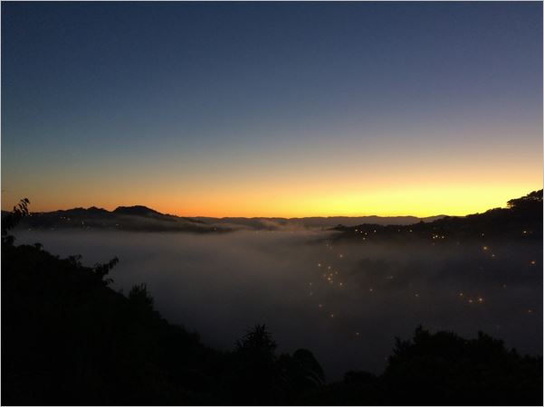 Valley fog u
The Big Tease
Summertime convection
The Northland lee trough
Many Auckland boaties head north for the summer break, up to the Bay of Islands and sometimes beyond, to the Cavalli Islands and Whangaroa Harbour. The prevailing southwest winds should mean a run up the coast. Right? Wrong. You need to know about the Northland lee trough.
MetService & Victoria University Offer New Master’s in Meteorology
January 2017.
Eight new trainees had their first day at MetService on January 25th 2017, welcomed by MetService and Victoria University staff, including MetService CEO, Peter Lennox and Victoria University's Associate Dean of Science, Shona De Sain.
Do you suffer from Cloud Envy?
Different parts of New Zealand are prone to different types of cloud. Use this handy guide to determine what types of cloud you get in your area, and where to go for some variety!
Near to the mountains
What is a storm?
The word ‘storm’ is frequently misused in the media and colloquially, almost as much as the misuse of the term ‘weather bomb’*. In the strictest meteorological sense, a ‘storm’ is only a storm if accompanied by storm-force winds, which are defined by the Beaufort scale as having an average speed of over 47 knots (88 km/h). However, there are several other types of storm which don’t require storm-force winds.
Understanding the long range forecast
Resolution counts
Weather forecasting is basically an ‘initial value problem.’ This means that if weather models could capture the current weather perfectly i.e. correctly initialise the current state of the atmosphere, then in theory, they could forecast the future weather accurately well beyond the present limit of a week or so. After all, the atmosphere is a fluid, and follows strict laws of physics.