While the weather conditions that lead to the formation of fog are usually quite benign, fog itself can be very disruptive. In particular the aviation and marine industries are often interested in how fog or mist will affect the visibility for their journeys, though fog also affects road-users. Fog can also make for some excellent photography opportunities, creating an eerie backdrop (as you can see in some of the photos below!)![]() A ‘fogbow’, photographed in the Waipa District by Peter Urich. To find out how a fogbow is formed, take a look at this blog on atmospheric optics.
A ‘fogbow’, photographed in the Waipa District by Peter Urich. To find out how a fogbow is formed, take a look at this blog on atmospheric optics.
But what is fog, and how is it formed?
Before we can talk about what fog is, we first need to define a key factor of fog: visibility.
Visibility has a different definition at night time and at day time. The definition given by the International Civil Aviation Organisation (ICAO) is:
-
During day time, visibility is the greatest distance at which a black object of suitable dimensions situated near the ground can be seen and recognised when observed against a bright background,
-
During night time, visibility is given by the greatest distance through which light of around 1000 candelas can be seen and identified against an unlit black background.
Fog and mist are created by microscopic water droplets suspended in the air. These tiny water droplets scatter any light that passes through or past them, meaning that objects in the fog become hard to see. Fog and mist are then defined by how much the visibility is reduced. The ICAO definitions are:
Fog: a suspension of very small water droplets in air, reducing the visibility to 1000 metres or less.
Mist: similar to fog, however visibility will be reduced to no less than 1000 metres.
Haze is another phenomenon that can reduce visibility. However, this is a reduction in visibility caused by microscopic particles in the air, rather than by water droplets. For example, in New Zealand we sometimes get haze around our coastlines after we have had strong winds, as the wind can whip up sea spray and cause small particles of sea salt to be suspended in the air.
So now we know what fog is, how is it formed?
There are a number of processes that can cause fog, and fog is classified into different ‘types’ based on how it forms. The most common types are radiation fog and valley fog, followed by advection fog. We can also get post-frontal (or evaporation) fog and steaming fog.
Let’s take a look at the different types of fog in more detail:
Radiation Fog
Radiation fog is so-called as the formation process depends upon a balance of “radiative heat fluxes” (I’ll explain what this means below). Radiation fog usually forms overnight or early morning during the coldest hours of the day, and then dissipates after the sun comes up. It primarily forms over land but has been observed to form over shallow inlets and harbours as well. It is the most common type of fog we see in New Zealand.![]() Radiation Fog in Christchurch, photographed by Julienne Nacion.
Radiation Fog in Christchurch, photographed by Julienne Nacion.
For radiation fog to form, we need several ingredients:
-
Clear skies,
-
Light winds,
-
Sufficient moisture in the lowest layer of the atmosphere, near the ground.
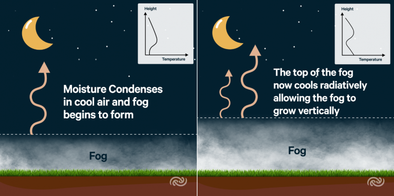
These conditions are most commonly met when we have high pressure over the country, but there are other situations where these conditions can be met too. In short, on a clear night with light winds, the air can cool down enough to reach its “dew point” (100% relative humidity) and water vapour in the air will start to condense into fog. Let’s have a look at this process in a little more detail.
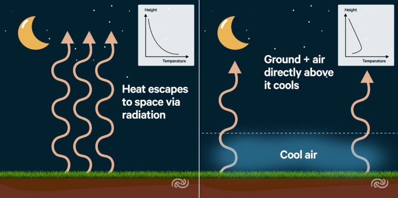
Radiative Heat Fluxes
The process of radiation fog formation starts at sunset, when the balance of radiative heat fluxes changes. Everything radiates heat – with warmer objects emitting more radiation than cooler objects. On a sunny day, incoming solar radiation is greater than the radiation emitted by the Earth back to space – this causes the ground and the air directly above it to warm up. On a cloud-less night, the Earth continues to radiate heat away to space – but with no incoming solar radiation, this causes the ground, and the air directly above it, to cool quickly.
Clear Skies
Cloudy skies change the radiative heat balance described above. If there is cloud in the sky, it will absorb the heat emitted by the Earth’s surface and re-radiate it back towards the ground. This prevents the land surface from cooling as much as it would on a cloudless night. Clear skies allow the ground to cool quickly by emitting heat to space via radiation, allowing a ‘temperature inversion’ to form (this is when the temperature increases with height, rather than decreasing with height like it usually does – more on inversions here.) Radiative cooling is an essential part of the formation of radiation fog, so the less cloud around, the greater the chances that fog will form.![]() Light winds
Light winds
If the wind is too strong, then this can cause warmer, drier air from aloft to be mixed up with the air near the ground, meaning that the land surface cannot cool as quickly.
Conversely, if there is no wind at all, you are more likely to get a very heavy dew instead of fog – this is because very light winds help to mix the cool air through a shallow layer of air near the land surface. If there isn’t enough wind, the cooling will be restricted to the lowest few centimetres of the atmosphere, allowing dew but not fog.
Sufficient moisture
The relative humidity in the lowest layers of the atmosphere needs to be high enough that radiative cooling overnight will allow the air to reach its “dew point”. The dew point is a measure of how much water vapour is in the air – when the dew point is equal to the air temperature, this is equivalent to 100% relative humidity, and the air cannot hold any more water vapour. In addition, warm air can hold more water vapour than cool air. If the air cools to its dew point, and then continues to cool, the water vapour needs to go somewhere – initially it condenses on the ground as dew, but if we have sufficient radiative cooling and light winds to mix the cool air through a shallow layer as described above, the water vapour will begin to condense into fog as well.![]() Shallow radiation fog by Addington Brook in Hagley Park, photographed by Don Gracia. The brook serves to provide a source of moisture in the lowest layer of the atmosphere, aiding the formation of fog.
Shallow radiation fog by Addington Brook in Hagley Park, photographed by Don Gracia. The brook serves to provide a source of moisture in the lowest layer of the atmosphere, aiding the formation of fog.
While having lots of water vapour in the lowest layer of the atmosphere helps fog to form, it is in fact beneficial for the air aloft to be quite dry. This is because water vapour in the air absorbs infra-red radiation, and, much like cloud, can re-radiate some of this heat back to Earth. This means that if the air aloft is dry, the land surface can cool much more efficiently.
 Many of our airports in New Zealand are prone to radiation fog, and our aviation forecasters spend a lot of time thinking about whether or not radiation fog is likely to affect each airport when night falls.
Hamilton Airport is our foggiest airport in New Zealand, with an average of 92.4 nights a year when fog is reported. This is followed by Dunedin Airport, with 64 nights a year.
Since it needs to be cool and damp for radiation fog to form, it is much more common during winter than summer. Auckland Airport shows a particularly strong seasonal trend – with only a couple of cases of fog occurring during the warmer months between September 20th and March 20th over the past ten years (all these cases were advection fog rather than radiation fog – you can find an explanation of advection fog later).
Radiation fog can be particularly disruptive when it occurs at Auckland Airport, which has an average of 19.3 foggy nights a year. While some aircraft are equipped to land in low visibility, taxiing around the runway is still dangerous in fog, and fewer aircraft can land per hour during low visibility operations. Another type of fog that can affect Auckland Airport is post-frontal fog, which is a special case of radiation fog.
Post-Frontal Fog (Evaporation Fog)
Suppose a front moves over an area, bringing cloud and rain. Sometimes, after a front has moved over, the skies clear up and the winds ease. If this occurs at night then the radiation fog formation process can begin.
In this case however we now also have water sitting on the ground, which can be evaporated into the air near the Earth’s surface, increasing the dew point of the air. This means that fog may start to form at slightly higher temperatures than it would have done had the ground been dry. The wet ground also means that fog can form without the need for dew.
![]()
The satellite image above was taken at 4.40pm on 3rd August 2018. The frontal cloud had cleared away from Auckland Airport shortly before sunset (you can see that it is beginning to get dark in the bottom right hand corner of the image). Following the front, the air was relatively cloud-free. This meant that Auckland Airport had a ready supply of moisture (water on the ground due to the front that had just passed over) and clear skies. The winds had also died back overnight creating the perfect conditions for fog. In this case, fog formed between midnight and 2am, persisting until the sun came up the next day and clearing around 8am.
Valley Fog
Valley fog is another special case of radiation fog. The formation process also relies on the land surface cooling by emitting radiation to space, allowing the air to reach its dew point temperature and causing moisture to condense.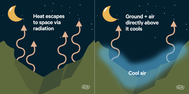
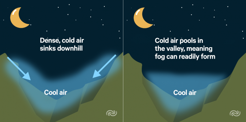
Most people know that warm air rises. This is because warm air is less dense than cool air – it weighs less, and therefore becomes buoyant and rises above the cool air. Equally, cold air sinks. In hilly areas, on a calm and cloudless night, the land surface on the hills cools. This in turn cools the air directly above it. The cooler air then sinks down into the valleys, much like water flowing through a river. Pooling of cold air means that fog can form more quickly, and persist for longer, in valleys than over flat terrain. At times in the Winter, some valleys or basins (for example, the Mackenzie Basin) will see fog that persists for days, and does not even clear during the height of the day. This is because the weak sunshine is not enough to warm the extensive pool of cold air sitting in the valley.![]() Valley fog, Dovedale River, Tasman District. Photographed by Sheryl Waters.
Valley fog, Dovedale River, Tasman District. Photographed by Sheryl Waters.
![]() Valley fog in the Wakatipu Basin, photographed by Marin Corinthian Kohn.
Valley fog in the Wakatipu Basin, photographed by Marin Corinthian Kohn.
Advection Fog
The word ‘advection’ refers to the transfer of heat and moisture from one place to another by the wind. Advection fog primarily forms over the sea (also called sea fog), though we can get advection fog over the land sometimes as well. Let’s start with sea fog.
Sea fog occurs when the wind pushes warm, moist air over a cooler sea surface. The sea surface cools the air directly above it, causing water vapour to condense into fog. Around New Zealand, high pressure to the east of the country is a good situation for sea fog to form – with northeasterly winds bringing air down from the sub-tropics, across cooler waters. If the high pressure stays in place for a long time (called a blocking high), then the sea fog can persist over the water for many days.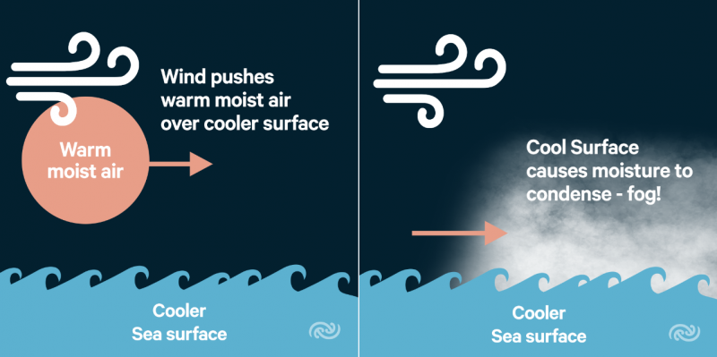
We learnt above that radiation fog forms after the sun sets and the land cools, and then dissipates when the sun comes up again the next morning. Unlike the land, the ocean is deep and dark, and it does not warm up and cool down as the sun rises and sets. For this reason, sea fog can happen at any time of day (and this is also why radiation fog will not occur over the sea).
But if sea fog doesn’t dissipate when the sun rises, what makes it go away? Essentially, we need an ‘air mass change’ – or another weather system to come along and push the sea fog away. Sea fog is most common during Spring, as the sea surface temperatures lag behind the increasingly warm land and air.![]() The satellite image above shows an area of sea fog sitting along the coast of Canterbury on the morning of 7th August 2018. You can see Banks Peninsula sticking out above the fog. Christchurch Airport reported fog overnight, which began to lift to low cloud early in the morning.
The satellite image above shows an area of sea fog sitting along the coast of Canterbury on the morning of 7th August 2018. You can see Banks Peninsula sticking out above the fog. Christchurch Airport reported fog overnight, which began to lift to low cloud early in the morning.
The satellite image below is an infra-red image of the same scenario. By measuring infra-red radiation, we can infer the temperature of the cloud tops or land surface. The red and green area to the west of the image indicates very cold temperatures of about -50°C. This is because this is part of a front, with cloud tops extending high into the atmosphere where it is very cold indeed.
You’ll notice that the sea fog doesn’t appear on the infra-red image – this is because it is very low to the ground, and therefore it is similar in temperature to its surroundings. The front coming from the west moved over the country later in the day, pushing away the sea fog, and no fog was reported at Christchurch Airport the following night.
![]() Hybrid Radiation-Advection Fog
Hybrid Radiation-Advection Fog
Those who live along our coastlines likely will have found themselves engulfed in sea fog from time to time. When extensive sea fog forms around our coasts over the sea, it can sometimes advect onto the land as well, but tends to dissipate on warm days as it moves further inland. Once sea fog has advected onto the land, it will likely show a slight diurnal variation – thinning out during the afternoon and becoming denser again overnight – this is called hybrid radiation-advection fog.
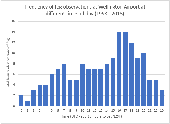
Wellington Airport is never affected by pure radiation fog but it is affected by sea fog on a handful of days a year. The graphs below compare the times of day when fog was observed at Wellington Airport (sea fog, though once it is over the airport it becomes hybrid radiation-advection fog) and Hamilton Airport (radiation fog alone). As you can see, Hamilton Airport has a very strong diurnal trend, with fog reported frequently at night, and very rarely in the afternoons. On the other hand, fog at Wellington Airport happens any time of day, with only a slight diurnal trend. You can read more about how fog occurs at Wellington airport here.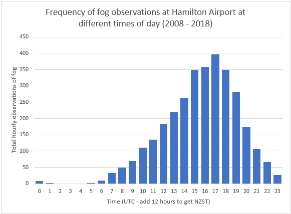
While sea fog that moves onshore becomes hybrid radiation-advection fog, we can also get radiation fog that forms over land, and then later advects over another area. This is also hybrid radiation-advection fog. For example, radiation fog frequently forms up the Hutt Valley, north of Wellington. In rare cases the radiation fog then drifts southwards across the harbour and over Wellington Airport in a light northeasterly drift. Hybrid radiation-advection fog that occurs at Wellington Airport via this process tends to be very short-lived, whereas sea fog that moves onshore at Wellington Airport can persist for most of the day.
Steaming Fog
The final type of fog I will explain in this blog is steaming fog. Steaming fog is also the rarest type of fog in New Zealand, and only occurs under very specific conditions. It tends to be very shallow, so is not as troublesome as the likes of advection fog or radiation fog. The best example of steaming fog around New Zealand would be steam rising from hot pools in places like Rotorua.
Steaming fog occurs when cold air lies over a much warmer water surface. Air close to the water surface is warmed and moistened by the water underneath. This makes the air buoyant (remember, “warm air rises” – this process is called convection). The air rises up and mixes with the cooler air slightly above it. If the increasing water content of the air outstrips the heating of the air from beneath, then the air can become supersaturated, and excess water vapour will condense into mist or fog.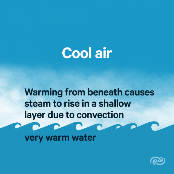
Here at MetService, we have dedicated marine and aviation meteorologists. There are also meteorologists who write the public weather forecasts on metservice.com, our app, the tv and newspapers. Each of these different disciplines have a different focus when it comes to forecasting fog, and forecasters spend a lot of time thinking about how fog will affect the people they are forecasting for. Marine forecasters look for situations where extensive sea fog is likely. Radiation fog is less of a concern for our marine forecasters, but sometimes radiation fog can form over the likes of Manakau Harbour. Meanwhile, aviation forecasters spend a lot of time thinking about radiation fog, but if sea fog is looking likely to move onto the coast, then they need to take this into consideration also.
While the processes behind fog formation are generally well understood, it can still be very difficult to forecast. Any error in the temperature forecasts or humidity forecasts can drastically change the likelihood of fog forming. To forecast fog perfectly, you would also need a perfect forecast for the cloud cover, temperature, humidity, and wind speed. You also need to know whether the ground will be wet or frosty.
Weather models alone are not currently able to resolve weather conditions on a small enough scale to accurately depict the risk of fog. Therefore it comes down to our meteorologists’ experience and knowledge, together with local observations of the conditions on the ground. Because of this, fog can be very challenging to forecast – but it also makes it more rewarding when you get a fog forecast just right!