The Auckland forecast for Monday 12 October 2015 included mention of the following: '... isolated showers ...' and ' ... southwesterly winds ...'. From time to time you’ll hear the word 'isolated' in weather forecasts, so let’s see what it means with reference to observational data, some of which is available on www.metservice.com.
Chris Webster
Maths, Physics and Meteorology
When recruiting and training people to become meteorologists, MetService requires that trainees hold a university science degree in maths and physics. Why maths and physics? First and foremost, meteorology is a science, and we need people in our National Forecast Centre who are capable of applying the scientific thinking that they’ve developed at university to understand the state of the atmosphere. Let’s look at specific examples of why maths and physics are important to meteorology.
The physics of fog
Convergence Lines and Sea Beezes
In the English language we have many words in common usage that have related but more specific meanings in a scientific and mathematical context. The key word of this blog post, “convergence”, is a good example of this. We sometimes hear of people’s views on some matter initially disagreeing and then, later, coming together or “converging”. In fluid dynamics we’re often interested in regions where different air flows come together. We call this type of flow convergence, and say that the air is converging.
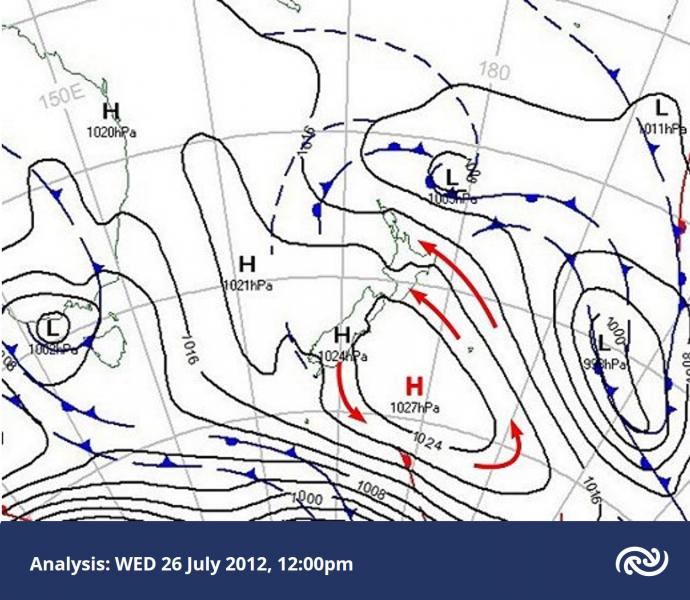
Cloud structures over NZ on 26 July
On Thursday 26 July 2012 a cold southeasterly airstream flowed onto the North Island, around an anticyclone centred just east of the South Island.
In this blog post we’ll look at some interesting small-scale cloud structures around the country on this day.
Below is the weather map at midday on Thursday 26 July. The red arrows show the sense of the broad-scale rotation around the anticyclone.
Not all Highs bring sunny weather
On Thursday 19 April 2012, New Zealand was completely surrounded by a very large High (or anticyclone). The air pressure at sea level was above 1030 hPa everywhere over New Zealand at midday on that day. Highest pressures were over inland Otago and Canterbury, peaking at 1039 hPa. Christchurch Airport was reporting 1038.2 hPa ... that's very high indeed.
Up and away
Up, up and away in my beautiful, my beautiful balloon… So the song goes, but what’s it actually like way up high in the atmosphere? Could we humans live up there if we wanted to, or had to? I recall David Attenborough doing a great documentary in the series “The Living Planet” (“The Sky Above” episode, BBC) where he ascended beneath a very large hot-air balloon, complete with oxygen mask and equipment for sampling for life specimens. It was surprising to discover that small insects could be whisked up there and freeze, before descending again and reviving.
The Foehn Wind
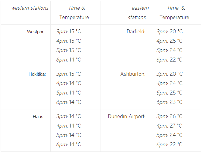
On Saturday 16 October 2010, many parts of New Zealand, especially South Island, experienced Foehn winds. During the approach to summer, eastern parts of both islands will get more warm Foehn winds under suitable conditions. In this blog post I'll describe what the Foehn wind is and explain how it comes about. We'll start by looking at temperature reports from weather stations on Saturday 16 Oct 2010.
Charles Kingsford Smith
A recent visit to Sydney International Airport has inspired me to write a little about another famous aviator with a New Zealand connection. Last year I wrote a post about Jean Batten who, in her youth had met the topic of this post, Charles Kingsford Smith. Auckland International Airport is named in honour of Jean Batten and likewise Sydney International Airport is named after Charles Kingsford Smith.
Rain or Showers
We had an enquiry from an astute member of the public asking about the comings and goings of rain. They had noticed that in southerly weather the rain has a tendency to "come in bands (e.g., 20 minutes rain, 20 mins dry, 20 mins rain etc.) rather than as a more constant rain that comes with northerlies". They were wondering why this was. This is a good question and I will try to answer it here.
A Lot of Rain
There was a lot of rain in many parts of New Zealand over the last two weeks of May 2010. One of the few places to escape this was the sunny West Coast of South Island - the days are clear and stunning there when the flow is southeasterly. If you had been following the surface weather maps during May you would have noticed a lot of low pressure over the Tasman Sea and northern NZ, and periods of relatively high pressure farther south.