The Auckland forecast for Monday 12 October 2015 included mention of the following: '... isolated showers ...' and ' ... southwesterly winds ...'. From time to time you’ll hear the word 'isolated' in weather forecasts, so let’s see what it means with reference to observational data, some of which is available on www.metservice.com.
Upper air data. The meteorological balloon sounding from Whenuapai at midday on 12 October showed moist air in the low levels of the atmosphere and dry air above. There was a temperature inversion at 1800 metres (6000 ft) above the ground, and the air was very dry above that level. In this case we would expect no cloud above a height of 1800 m. By the way, the surface temperature was 16°C when the balloon was released, cooling to 1°C before rising steeply to 3°C as the balloon climbed through the inversion. The temperature continued to cool above that, until it hit the tropopause.
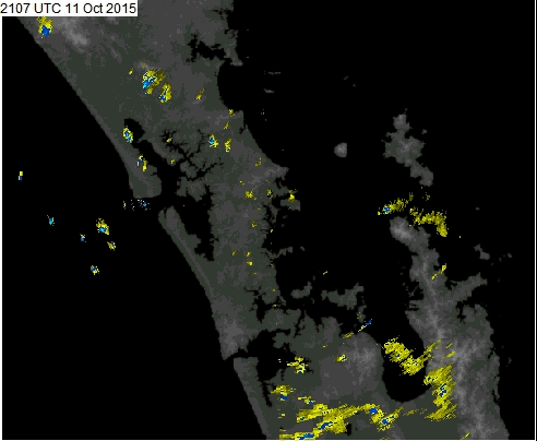
Radar loop from 10:07 am – 12:15 pm Monday 12 October 2015
 Animation of Auckland radar imagery
The time-stamp on the radar images is in UTC, and NZ is now in Daylight saving time so:
- the loop starts at 2107 UTC = 10:07am on Monday 12 October, and
- finishes at 2315 UTC = 12:15pm just after noon.
The radar loop comes from our weather radar sited on Mount Tamahanga, north of Auckland. The loop of imagery shows:
- the nature of the showers, with small yellow dots moving across the Auckland area in the southwesterly flow,
- most of the showers are light and brief in duration, but a few of the dots have blue centres indicating light to moderate intensity,
- there is a faint yellow line flickering to the south of the radar (bottom middle of image) – this is an anomalous echo that is not generated by showers.
Satellite imagery loop from 10:10 am – 12:10 pm Monday 12 October 2015
Now let’s have a look at the corresponding images from Himawari-8 in visible wavelengths of light. Here all cloud shows as white or a shade of grey, and what we see is sunlight reflected off clouds and the Earth’s surface.
 Visible satellite animation, courtesy of JMA
The imagery shows:
- lenticular lee-waves being generated at low-levels by the Kaimai ranges,
- a lot of cloud over and east of Northland – this is stratocumulus cloud,
- large areas of clear sky upwind (over Tasman Sea), so most of the cloud over Auckland and Waikato is forming as the low-level moist air moves onto the land,
- over Auckland the clouds are generally a little lumpier in texture, which is consistent with the showers appearing on the radar. These clouds are cumulus, and there is evidence of some ‘streeting’ as some of the cumulus line up into bands parallel with the wind flow (see my previous post for another example of cloud streets).
The quality of satellite imagery is quite amazing, especially when you consider that the satellite sensors are rotating around the Earth 36,000 km above the equator! Showers are common around Auckland, and showers can occur even in situations where you might expect a nearby anticyclone to suppress them. Earlier in this post I mentioned the temperature inversion. The detailed nature of the inversion has a strong influence on the showers. Today the inversion has not been strong enough to stop the showers forming. Typically, as a ridge of high pressure advances onto the region, the inversion gets strong enough to suppress any showers. This is usually the reasoning behind the forecast mentioning showers becoming isolated in southwesterly flows, and/or a clearance of the showers.