August 2012
One evening, having just arrived home after the short walk from Trentham Station, I remarked to my family that it was unusual for the wind to blow from the northeast in Upper Hutt. Five days later and it was still blowing from there.
August 2012
One evening, having just arrived home after the short walk from Trentham Station, I remarked to my family that it was unusual for the wind to blow from the northeast in Upper Hutt. Five days later and it was still blowing from there.
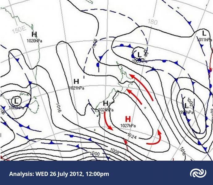
On Thursday 26 July 2012 a cold southeasterly airstream flowed onto the North Island, around an anticyclone centred just east of the South Island.
In this blog post we’ll look at some interesting small-scale cloud structures around the country on this day.
Below is the weather map at midday on Thursday 26 July. The red arrows show the sense of the broad-scale rotation around the anticyclone.

Sunny weather dominated the country due to a large anticyclone covering the country and the Tasman Sea during the second week of July 2012.
Written by Erick Brenstrum and first published in New Zealand Geographic 96, March-April 2009
We think of Benjamin Franklin as American, but for the first seventy odd years of his life he thought of himself as British. In turn, the British thought him one of theirs and embraced Franklin’s ideas and inventions as British discoveries.
Introduction
This short article is in response to an emailed complaint about temperatures displayed on the Christchurch Towns & Cities page on Thursday evening, 24 May 2012.
Sent: Thursday, 24 May 2012 10:26 p.m.
To: Enquiries
Subject: Christchurch weather issues!
Dear sir/madam,
On Thursday 19 April 2012, New Zealand was completely surrounded by a very large High (or anticyclone). The air pressure at sea level was above 1030 hPa everywhere over New Zealand at midday on that day. Highest pressures were over inland Otago and Canterbury, peaking at 1039 hPa. Christchurch Airport was reporting 1038.2 hPa ... that's very high indeed.
It's been a while since a rapidly-deepening low passed close to, or over, New Zealand. I thought it might be interesting to take a quick look at why the "bomb" low of Saturday 03 March 2012 deepened so quickly and why the winds around it affected the areas they did. First of all, here is a series of weather maps covering the period 1pm Friday 02 March to 1am Sunday 04 March.
On Monday 28th November 2011, a south to southwest change swept its way northwards across Otago and Canterbury during the afternoon. Temperatures soared to 28°C preceding this change then rapidly plummeted to around 16°C. This was a good example of what is known in Australasia as a ‘buster'.
Up, up and away in my beautiful, my beautiful balloon… So the song goes, but what’s it actually like way up high in the atmosphere? Could we humans live up there if we wanted to, or had to? I recall David Attenborough doing a great documentary in the series “The Living Planet” (“The Sky Above” episode, BBC) where he ascended beneath a very large hot-air balloon, complete with oxygen mask and equipment for sampling for life specimens. It was surprising to discover that small insects could be whisked up there and freeze, before descending again and reviving.
This blog post was written by Wayde Beckman from the Health Sponsorship Council (HSC).
New Zealanders have access to an easy-to-use tool that tells them when they need to protect their skin from the sun, with specific reference to which regions of Aotearoa New Zealand they live. Using extensive research as well as audience and media feedback, the HSC has worked with the MetService and NIWA, in consultation with the Cancer Society, to produce a UV radiation public communications tool – called the Sun Protection Alert to replace the UV Index.