On Monday 28th November 2011, a south to southwest change swept its way northwards across Otago and Canterbury during the afternoon. Temperatures soared to 28°C preceding this change then rapidly plummeted to around 16°C. This was a good example of what is known in Australasia as a ‘buster'.
 Temperature traces on 28 November in degrees Celcius. DNA=Dunedin, OUA=Oamaru, TUA=Timaru, CHA=Christchurch and KIA=Kaikoura. Timestamp is in UTC; 27 0000 is 1pm NZDT.
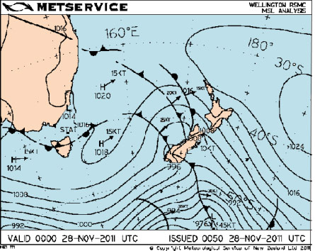
The weather map for 1pm Monday 28 November 2011 showed a typical trough moving across New Zealand. The last of a series of fronts within this trough was the one responsible for this dramatic drop in temperature.
 Weather map for 1pm NZDT Monday 28 November
The reasons for temperatures soaring to between 26°C and 28°C ahead of this southerly change are:
- Northwest winds ahead of the trough warmed by around 5 to 10 degrees Celsius as they descended down the eastern slopes of the Southern Alps
- Sunny conditions in the relatively clear skies over the Canterbury Plains – on a date less than one month ahead of the longest day.
These warm temperatures combined with falling air pressure to produce a zone of relatively low density. Higher density air in the cooler southerly flow that followed this cold front accelerated into this zone of low density air producing a squally “gust front” with the wind change. This “gust front” built in size and intensity during the afternoon as can be seen from the tweets sent from @metservice during the afternoon
- Southwest change arrived Dunedin Airport around 11:50am. Temp dropped from 22 to 14 C , gusts to 50 kph , and its on its way north. ^BM
- Southerly change got to Oamaru about 1:30 pm, temp. dropped from 22 to 14 C, initial gusts were 54 kph . South Canterbury's next ^BM
- Southwest change arrives in #Timaru just before School's out, Temperature drops from 28 C at 2:30 pm to 16 C by 3 pm , Gusts to 70 kph ^BM
- Southerly change reached #Ashburton between 3:30 and 3:45 pm, temp. dropped from 26 to 16 C, gusts 70 kph ^BM
- Southwest reached #Christchurch at 5 pm in time for evening commute, temps 28 C to 17 C in 20 minutes. with wind gusts 75 kph , ^BM
- Hi #Christchurch be quick and look at wind blown dust of that southerly change on MetService radar ^BM
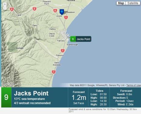
Click here to follow us on Twitter. September to November is the season for the strongest of these southerly busters (but they can occur at any time of the year). Spring brings the strongest westerly winds of the year to South Island and it is also a time of relative cold offshore sea temperatures. The temperature difference between the heated air over the Canterbury Plains and seas in the Canterbury Bight is what feeds the wind gusts of a buster. The coldest sea temperatures of the year occur in early spring, and they only just start rising in November. You can find the latest reading from metservice.com by clicking on ‘marine’ and then ‘beach’ and selecting a suitable site. The one shown below is Jack's Point near Timaru (timestamp is 10am Wed, 30 Nov 2011).
 Jack's Point on the metservice.com Marine & Surf section. Wind, Wave ands Sea conditions are now available on metservice.com