If you were looking at radar imagery overnight Thursday 21 February 2013 or this morning (Friday 22 February 2013), you could be forgiven for thinking that there was quite a lot of light precipitation over the northern half of the North Island and west of Auckland.
Blogs
It’s a fine day. Isn’t it?
What do we mean when we say the weather is “fine”? The word fine is often used to convey the positive attributes of something. It is synonymous with good, well, enjoyable.
How are you? I’m fine!
How was the movie? It was fine.
This is a fine bottle of wine.
When we write weather forecasts we define the term fine to mean that the sun casts sharp shadows. If cloud is thick enough to stop the sun from casting sharp shadows then, even if it doesn’t rain, we don’t think that’s a fine day.
Weather Place Names
Written by Erick Brenstrum and originally published in the New Zealand Geographic Issue 111 Sept-Oct 2011
Our Weather Stations – considerations about their location
During spells of fine sunny weather, there are often many comments about the air temperatures shown on our web site, where they are measured, and opinions about them. In this Blog post I will explain the reasons for the location of our weather stations. I will also offer some help about how you can get some use from the information they provide.
MetService in the Tropics
This post looks at some of MetService's activities in the southwest Pacific, particularly a severe weather project and the training we have provided to individual countries over the last 7 months.
Convergence Lines and Sea Beezes
In the English language we have many words in common usage that have related but more specific meanings in a scientific and mathematical context. The key word of this blog post, “convergence”, is a good example of this. We sometimes hear of people’s views on some matter initially disagreeing and then, later, coming together or “converging”. In fluid dynamics we’re often interested in regions where different air flows come together. We call this type of flow convergence, and say that the air is converging.
Not all El Niños are the same
This blog created just prior to spring 2012.
The phrase La Niña was possibly heard a lot during the Summer of 2011-12, going into spring 2012 another similar term is El Niño. We all know that El Niños bring different types of weather to New Zealand compared to La Niñas but what is an El Niño? Does it always mean the same sort of weather for New Zealand? Not necessarily - The season of 2012-13 might not have the typical sort of El Niño weather. So what is a typical El Niño?
MetService’s role in monitoring volcanic ash
The August 7th 2012 eruption at Mount Tongariro set in motion MetService’s volcanic ash monitoring process for the aviation industry. The Volcanic Ash Advisory process involves interaction between aircraft operators, Airways Corporation and MetService, with important volcanic information input from GNS Science.
This information is also provided to Civil Aviation (CAA) and is used by them to designate Volcanic Hazard zones around those volcanoes that are known to be Volcanic Alert Level 1 or higher.
Unusual Wind Direction
August 2012
One evening, having just arrived home after the short walk from Trentham Station, I remarked to my family that it was unusual for the wind to blow from the northeast in Upper Hutt. Five days later and it was still blowing from there.
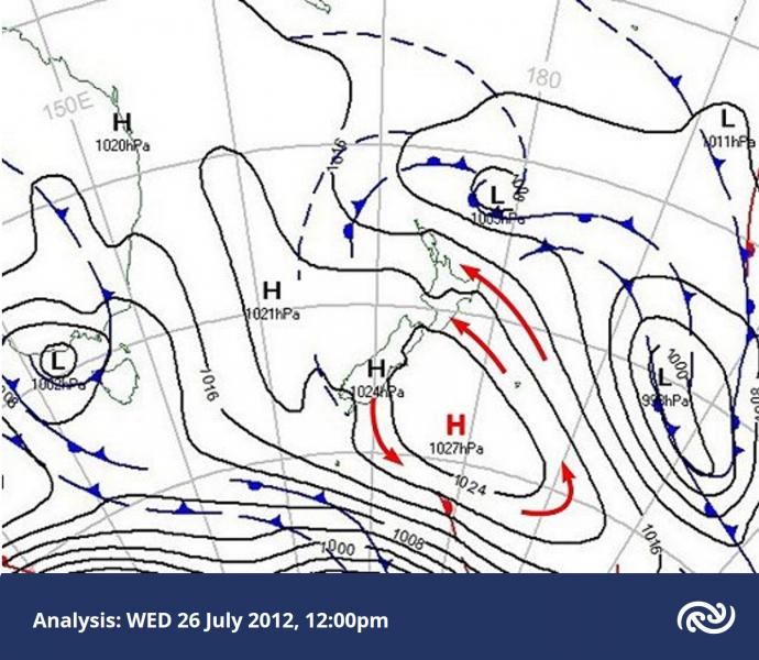
Cloud structures over NZ on 26 July
On Thursday 26 July 2012 a cold southeasterly airstream flowed onto the North Island, around an anticyclone centred just east of the South Island.
In this blog post we’ll look at some interesting small-scale cloud structures around the country on this day.
Below is the weather map at midday on Thursday 26 July. The red arrows show the sense of the broad-scale rotation around the anticyclone.