We had an enquiry from an astute member of the public asking about the comings and goings of rain. They had noticed that in southerly weather the rain has a tendency to "come in bands (e.g., 20 minutes rain, 20 mins dry, 20 mins rain etc.) rather than as a more constant rain that comes with northerlies". They were wondering why this was. This is a good question and I will try to answer it here.
Radar examples
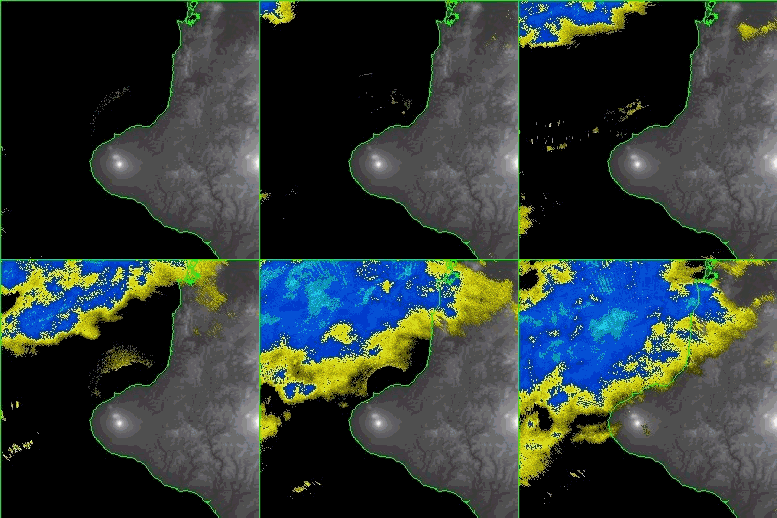
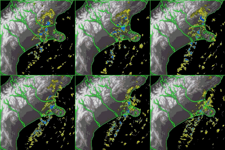
First, let's have a look at examples of northerly and southerly precipitation. Below are radar images that show rainfall-sized drops as explained in an earlier post on the storm of late May. As before, light falls are yellow and heavier falls blue.
1. Rain approaching Taranaki from the north on 5 June 2010. In this animation the precipitation is relatively uniform, suggesting more continuous rain:
 New Plymouth radar imagery, 6pm to 10:30pm NZ Standard Time, 5 June 2010
As an aside, the semi-circular area of yellow over the North Taranaki Bight (towards the end of the animation) is caused by cluttering reflection off the sea.
2. Showers moving onto the Canterbury coast and plains from the south on 8 June 2010. Here the precipitation is speckled indicating showers (with breaks in between): Christchurch radar imagery, 6pm to midnight NZ Standard Time, 8 June 2010
The key to unlocking the cause of the difference between rain and showers lies in the nature of vertical motion. In the post on The Structure of Highs I explained the importance of up and down motion of air. Even though vertical motion is usually much weaker than horizontal motion of air (wind), it really dictates the state of the sky:
-
upward motion of moist air favours the formation and maintenance of cloud, and possibly precipitation too,
-
downward motion of air inhibits cloud, favouring clear skies.
Relating this to our original question, northerly flows over New Zealand occur ahead of approaching depressions or troughs of low pressure. These flows are characterized by gently rising warm moist air covering a large area. In these situations you're more likely to get continuous rain.
In contrast, southerly flows occur immediately behind departing depressions or troughs, where there tend to be pockets of more vigorously rising air surrounded by generally sinking clear air. In addition, if the air flows over the sea, the colder drier air picks up extra moisture and becomes unstable so that the rising air gets extra buoyancy. In these situations the precipitation is likely to be punctuated with breaks, i.e. you're more likely to get showers.
Combinations and exceptions
There are some complications to this. Occasionally within the gently rising northerly airstream there are pockets or bands of vigorous rising air that can even generate embedded thunderstorms. These are caused by subtle instability mechanisms. They are of great interest to pilots, because the surrounding rainy areas can make the embedded and hazardous thunderstorms difficult to detect.
It's also possible to have an approaching front generating a broad area of rain as it flows over the top of an older shallow flow generating light showers. I can show you an example if you're interested - just leave a comment below.
Topographic effects can lead to preferred places for showers in southerly flows. For example, have another look at the radar animation of showers above. Note the band of showers over the Canterbury Plains at the western edge of the radar echoes. This is caused by a low-altitude convergence effect that favours upward motion there. There are no showers farther to the west due to sheltering from the eastern Otago ranges. If you are beneath that band of showers, then it will seem more like continuous rain than passing showers.
Another common situation for showers to behave more like continuous rain is when an unstable airmass flows onto the West Coast - in these conditions the cloud is often continuous, and the precipitation is too, with alternating periods of heavier and lighter rain.
If you look very closely at the second animation you may detect a slight change in the orientation of the band of showers - it turns a few degrees of angle clockwise and crosses Christchurch. This turning is caused by a small clockwise shift in the direction of the wind flow. Subtle changes like this are a real challenge for our forecasters, but our growing network of weather radars is increasing our ability to forecast them.