We all look out the window to see what the weather is up to. In a similar way, MetService meteorologists are always checking to make sure what they have predicted is actually happening.
We all look out the window to see what the weather is up to. In a similar way, MetService meteorologists are always checking to make sure what they have predicted is actually happening.
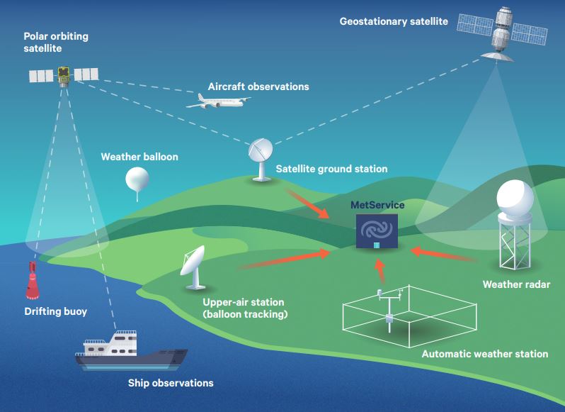
Weather radars are used all around the world to detect rain, hail and snow, as it happens. However, there are times when the radar network can pick up other things as well. While you generally won't see aeroplanes on our radar images (the radar beam is usually beneath the flight path of most flights, and also our radars are calibrated to primarily pick up smaller objects, whereas radars at airports are calibrated differently to primarily pick up aeroplane-sized objects), there is a myriad of other things that can cause interference on our radar images, which I will explain in this blog.
Here is an explainer on the difference between the rain radar imagery and rain forecast imagery available on metservice.com and how to use them.
Rain radar
The term RADAR stands for RAdio Detection And Ranging and was coined in 1940 by the United States Signal Corps, although it was German physicist Heinrich Hertz who showed that radio waves could be reflected from solid objects, in around 1886. During World War II, radar technology developed rapidly and has since become an essential tool in meteorology, as well as in other areas such as air traffic control.
The development of modern radar started in 1886, when German physicist Heinrich Hertz showed that radio waves could be reflected from solid objects. In 1904, another German, Huelsmeyer, was the first to build a simple ship detection device, successfully detecting a ship in dense fog. In the pre-war period (the 1930s), many nations were working on radar devices. A major advance occurred once systems were developed that allowed short ‘pulses’ of radio energy to be generated, allowing the range of the object to be determined by timing the pulses.
MetService’s long-range weather radar, situated near Kaeo in Northland, officially commenced operations on Monday 28 July 2014, with early imagery from the radar enabling MetService forecasters to provide very valuable information to Civil Defence and the public ahead of the June storms experienced in the region that year.
On Monday 28th November 2011, a south to southwest change swept its way northwards across Otago and Canterbury during the afternoon. Temperatures soared to 28°C preceding this change then rapidly plummeted to around 16°C. This was a good example of what is known in Australasia as a ‘buster'.
Written by Chris Webster, Meteorologist
We had an enquiry from an astute member of the public asking about the comings and goings of rain. They had noticed that in southerly weather the rain has a tendency to "come in bands (e.g., 20 minutes rain, 20 mins dry, 20 mins rain etc.) rather than as a more constant rain that comes with northerlies". They were wondering why this was. This is a good question and I will try to answer it here.
From Wednesday 01 July 2009, MetService has been providing a Severe Thunderstorm Warning Service. This blog entry explains why we are able to do this, why warnings of thunderstorms are different from warnings of broad-scale weather events, which parts of New Zealand they will apply for, how you can receive them and what actions you can take to protect yourself.