From Wednesday 01 July 2009, MetService has been providing a Severe Thunderstorm Warning Service. This blog entry explains why we are able to do this, why warnings of thunderstorms are different from warnings of broad-scale weather events, which parts of New Zealand they will apply for, how you can receive them and what actions you can take to protect yourself.
Why does MetService provide a Severe Thunderstorm Warning Service?
Over the six years or so prior to 2009, four important developments at MetService have together made it possible to provide a warning service for localised severe weather:
- Expansion and enhancement of the weather radar network
- "Next generation" radar processing tools
- Fast, automated tracking tools for severe thunderstorms
- Thunderstorm forecasting methods and forecaster expertise.
What is “localised severe weather”?
Most of New Zealand’s severe weather is brought about by big weather systems like lows and fronts. But some severe weather events are the result of severe thunderstorms. Severe weather that is related to thunderstorms usually occurs over a much smaller area, and lasts for a much shorter time, than severe weather related to lows and fronts. This is because thunderstorms are much smaller weather systems than, and last for much less time than, lows and fronts. But the sheer intensity of the rainfall, hail and/or wind associated with some thunderstorms can pose just as big a threat to life and property.
Below is an example of the difference in scale. Broad-scale heavy rainfall over northern New Zealand (the first image) is of far greater extent than a local severe thunderstorm in coastal Bay of Plenty (the second image, circled).
 Heavy rainfall over almost all of Northland and parts of Auckland and Coromandel, 7:21am 10 July 2007. Overall, this heavy rainfall event lasted at least a day. According to the Insurance Council of New Zealand, about $60 million in insurance claims resulted from this event.

Severe thunderstorm just east of Tauranga, 11:59 am 11 May 2009. This event lasted a few hours altogether, and much less than that in any one location. While there is a lot of echo on the radar scope, the small area near Tauranga is the only place where severe weather is occurring.
A narrow swath of heavy hail affected the Bay of Plenty coast from near Tauranga to near Opotiki. In locations more than about a kilometre from the thunderstorm, severe weather didn't occur.
When do severe thunderstorms occur?
In eastern and inland parts of New Zealand, severe thunderstorms primarily occur on some afternoons and evenings in spring and summer. In western parts of New Zealand, though, they can occur any time. For example, there were tornadoes in New Plymouth on 4 and 5 July 2007 – the middle of winter. And they can occur in the middle of the night.
The Warning System
The size and lifetime of a weather system (for example, low, front, thunderstorm) influences how far ahead in time the weather related to it can be forecast. The warning system for small-scale severe weather mimics that for broad-scale severe weather, as shown below. But when small-scale severe weather is expected, the forecast has much less lead time. 
How often do severe thunderstorms occur?
Thunderstorms occur reasonably often in New Zealand. Severe thunderstorms are much less common, occurring perhaps once a month or less. Your chances of experiencing one are fairly small. But if you are under or near one, it is important that you know what to do to try and keep yourself and your property safe.
What can I do with less than 60 minutes’ notice?
Quite a lot. A few simple examples are:
- Torrential Rain: If you're in a narrow watercourse or working in a stormwater drain, get out of it
- Very strong winds: If you're up on the roof, get down, secure loose roofing iron and other potentially dangerous flying objects
- Lightning: Go inside, or at least stay away from trees which are out in the open
- Hail: If you're driving, be ready to slow down or stop
How does MetService detect thunderstorms?
Weather radar is essential for the detection and forecasting of small-scale severe weather events. The amount and quality of data decreases with distance from a weather radar. For these reasons, warnings of severe thunderstorms will only be available within about 150 kilometres of a weather radar.
How many weather radars does MetService have, and where are they?
In the map below, the bright blue areas are both within 150 km of a weather radar and contain enough weather radar information to provide Severe Thunderstorm Warnings. Siting weather radars in New Zealand is a challenge because hills reduce, or in some cases completely block, the radar signal. This is why, for example, the Canterbury radar provides no coverage of the South Island West Coast.
MetService weather radar network as of 2012
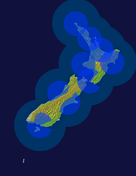
Weather radars have since been installed on Mahia Peninsula and Otago.
Who does the warnings?
MetService has a group of very experienced forecasters whose focus is severe weather. Every day, one of the things they do is issue the Severe Weather Outlook and the Severe Thunderstorm Outlook. The Severe Weather Forecasters issue Watches or Warnings when they expect the warning criteria to be met.
Severe Thunderstorm Warnings are a bit different …
Because they are not based on radar information, the Severe Thunderstorm Outlook and Severe Thunderstorm Watch are available New Zealand-wide. In contrast, Severe Thunderstorm Warnings are referenced to radar areas. Further, no Severe Thunderstorm Warning will be issued for a location greater than 180 km from any of New Zealand's weather radars. A Severe Thunderstorm Warning will only be issued once a severe thunderstorm exists and can be tracked. This might be 30 minutes after it developed. In other words, by the time you receive a Severe Thunderstorm Warning, there is already a severe thunderstorm.
How can I receive Severe Thunderstorm Warnings?
Because Severe Thunderstorm Warnings will have short lifetimes, they need to be delivered as quickly as possible. They will be available
- On www.metservice.com
- By email (words only; no picture) via publicly subscribable email list
- To the media
Severe Thunderstorm Warnings will be based around weather radars rather than around districts. That is, the occurrence of a severe thunderstorm within, say, the Wellington radar area will prompt the issue of a warning for the Wellington radar area. Prominent in the warning heading will be the location it applies to (e.g., Blenheim, Paraparaumu, Upper Hutt, etc).
Appendix I: Example
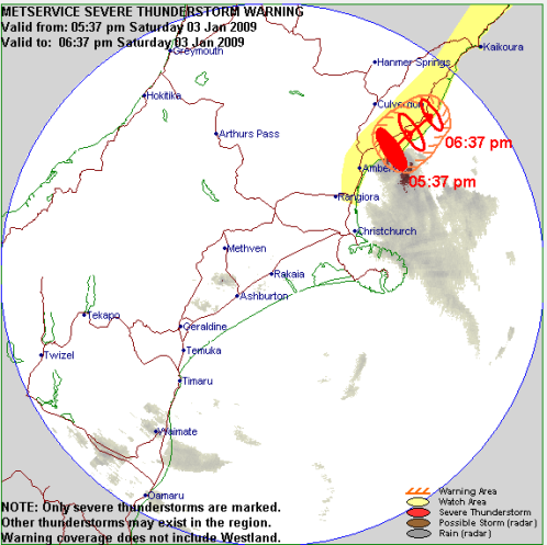 SEVERE THUNDERSTORM WARNING TOP PRIORITY FOR IMMEDIATE BROADCAST Issued by MetService at 5:53 pm Saturday 03 January 2009 Valid until 6:37 pm Saturday 03 January 2009 This warning affects people in the following local government areas: HURUNUI. At 5:37pm, MetService weather radar detected severe thunderstorms near MOTUNAU BEACH, PEGASUS BAY, SCARGILL and GRETA VALLEY. These severe thunderstorms are moving towards the northeast, and are expected to lie near CHEVIOT, DOMETT and BLYTHE VALLEY at 06:07 pm and near CHEVIOT and OFFSHORE HURUNUI at 06:37 pm. These thunderstorms are expected to be accompanied by very heavy rain and large hail. Very heavy rain can cause surface and/or flash flooding about streams, gullies and other low lying areas, as well as make driving conditions extremely hazardous. Large hail can cause significant damage to crops, orchards, vines, glasshouses and vehicles, as well as make driving conditions hazardous. Very heavy rain associated with this storm has been reported earlier from CHRISTCHURCH RADAR BUT THE TREND IS NOW FOR WEAKENING. Large hail associated with this storm has been reported earlier from CHRISTCHURCH RADAR TO AROUND 20MM DIAMETER BUT SIZE IS LIKELY NOW DIMINISHING. A Severe Thunderstorm Watch remains in force for FAR NORTHEASTERN CANTERBURY AND EASTERN PARTS OF MARLBOROUGH UP TO CAPE CAMPBELL. MetService advises that as storms approach people should:
- Take shelter, preferably indoors away from windows
- Avoid sheltering under trees if outside
- Move cars under cover or away from trees
- Secure any loose objects in the vicinity of your home
- Check that drains and gutters are clear
During and after the storm, people should:
- Beware of fallen trees and power lines
- Avoid streams and drains as you may be swept away in flash flooding.
This warning is due to be updated or lifted by 06:37 pm Saturday 03 January 2009. NOTE: Only severe thunderstorm tracks are shown in the graphic. Other thunderstorms may exist in the area. MEDIA PLEASE NOTE: This warning will be updated within the next hour or so. MetService would appreciate it being broadcast regularly during this period.
Appendix II: What is a thunderstorm, anyway?
A thunderstorm is a local storm produced by a cumulonimbus cloud. In the photograph on the right, the tall cloud in the middle of the frame with an anvil-shaped top is a cumulonimbus cloud. (And without weather radar, there is no way of knowing whether this is a severe thunderstorm … unless you’re underneath it).

Impressive cumulonimbus (thunderstorm) seen from MetService. Image courtesy Allister Gorman, MetService.
Thunderstorms are the result of strong updraught of air throughout a considerable depth of the atmosphere but over a small area. In New Zealand, thunderstorms tend to be associated with
- Vigorous, fast-moving cold fronts moving from west to east across New Zealand. These occur at any time of the year, night or day.
- Southerly changes along the east coast, especially Canterbury, and especially during the warmer part of the year.
- In both these situations, the thunderstorms are commonly arranged in lines along or near the front / southerly change.
- Afternoon and evening "build-ups" inland during the warmer part of the year.
- Humid north or northwest flows driven up over high ground.
- In these situations, the thunderstorms occur more randomly.
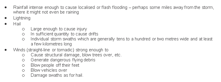
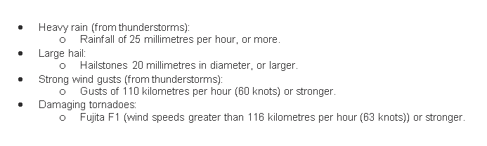
Appendix III: Severe Thunderstorm Criteria
A Severe Thunderstorm Warning will be issued when one or more of the following is expected
Appendix IV: Thunderstorm-Related Hazards