Clouds come in many different types and are characterised and named according to both their shape and height in the atmosphere. While a single snapshot in time at a given location may only contain one type of cloud, there are many days when multiple cloud types can be observed in the sky at once. The satellite images below is a nice example of different cloud types sitting at different levels above Waikato. Here's what the satellite image looked like Saturday afternoon 3 July 2010, for southwestern parts of Waikato near Kawhia Harbour:
Chris Noble
Thunderstorms!
The last week in January 2010 will be remembered by many over the central North Island for the frequent thunderstorms that developed in the afternoon, often lasting well into the evening. Conditions changed little during the week with a slack pressure gradient over the North Island allowing afternoon sea breezes to combine with abundant low level moisture, triggering heavy showers and thunderstorms inland. Many of these storms were slow moving, prompting a number of Severe Thunderstorm Warnings as radar detected torrential rain and hail in some cells.
Wellington Rainbow
With a superb view over Wellington and the harbour from the MetService building in Kelburn, we're often (and quite appropriately) treated to some fantastic weather related vistas. Here's a little sample, snapped on Monday 26 October 2009 as a few light showers passed over the city in a northerly flow late afternoon.
Canterbury Snow, 10 May 2009
With clear skies over most of Canterbury on Monday May 11th 2009, there was a good look at the fresh snow that fell the previous day, Sunday (10th May). Here's the view late Monday morning (around 10:30am) from NASA's Earth Observing System Terra Satellite,
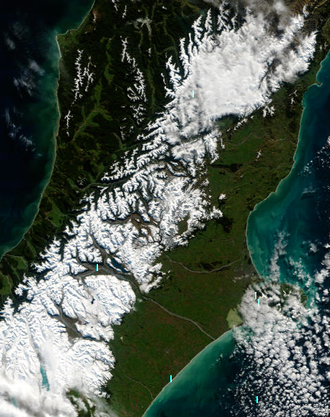 Fresh snow on the Alps and Canterbury foothills - as @ Monday 11 May 2009. (Image courtesy of MODIS Rapid Response Project at NASA/GSFC.)