A satellite receiver ("dish"), for improved reception of data from polar-orbiting weather satellites, was installed at MetService Head Office in Kelburn in February 2013.
Benefits
Polar-orbiting weather satellites yield rich information about the atmosphere, valuable for New Zealand weather forecasting. Benefits of faster access to more data, and sharper identification tools, include:
-
Better detection of airborne volcanic ash MetService operates the Wellington Volcanic Ash Advisory Centre (VAAC), on behalf of the Civil Aviation Authority of New Zealand. The better the tracking and forecasting of volcanic ash, the safer and more efficient is aviation in the New Zealand region.
-
Better detection of low cloud and fog Fog and low cloud – which can be particularly disruptive to aviation – are difficult to detect in the overnight and early morning hours, the time when airlines are planning the coming day’s flights. In the overnight and early morning hours, there are at least four polar-orbiting satellite passes over the New Zealand area.
-
Better analysis of severe weather Polar-orbiting satellite passes complement weather radar, providing high-resolution information about incoming weather features beyond the footprint of the radar network and which are too small to resolve using imagery from geostationary satellites.
An example
The two images immediately below demonstrate the difference in resolution, of visible imagery, between two of the weather satellites that view New Zealand. As explained later in this article, data from each type of satellite has its advantages.
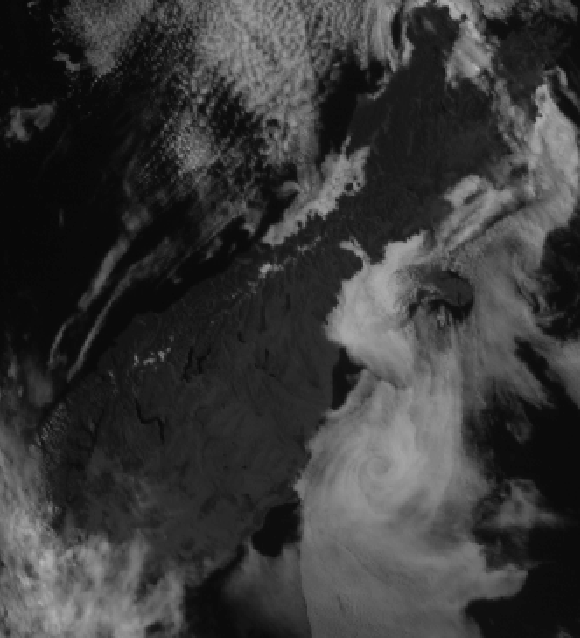 Visible image for 2300UTC 26-Feb-2013 (midday Wednesday 27 February, New Zealand Daylight Time) from the geostationary meteorological satellite MTSAT-2.
Data courtesy Japan Meteorological Agency.
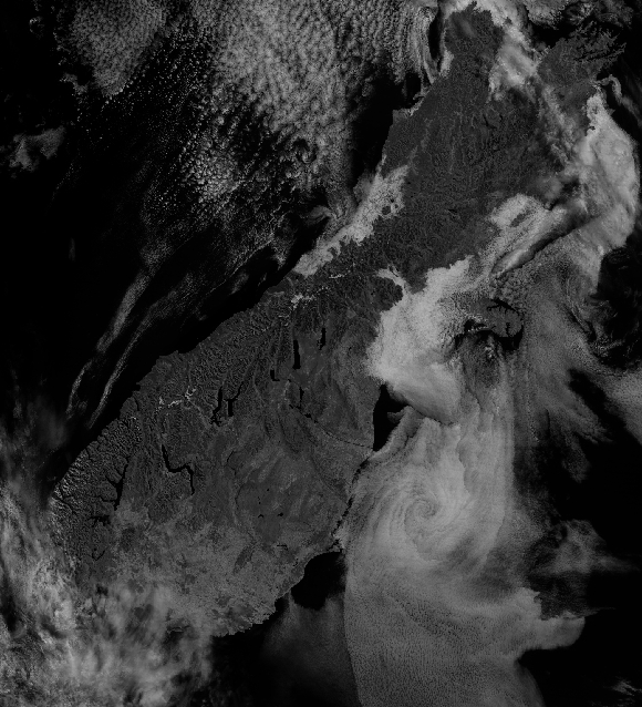 Visible image for 2244UTC 26-Feb-2013 (11:44am Wednesday 27 February, New Zealand Daylight Time) from the polar-orbiting meteorological satellite Terra.
Data courtesy National Oceanographic and Atmospheric Administration.
Satellites available
Using the new receiver, MetService currently gathers data from the Terra, Aqua and NOAA series of satellites. Their passes across the New Zealand area are generally clustered around early morning and late afternoon. Data from other polar-orbiting weather satellites is a work in progress.
More about polar-orbiting satellites
The animation below, from the National Oceanographic and Atmospheric Administration (NOAA), nicely demonstrates the differences in the orbits of polar-orbiting and geostationary satellites. Polar-orbiting satellites continuously orbit the Earth from pole to pole at low altitude (about 800 km). Because they are much closer to the Earth than geostationary satellites (about 36,000 km), they yield data at much higher resolution – that is, information from them is much more detailed. On the other hand, information from any given sun-synchronous polar-orbiting satellite is available much less frequently than from a geostationary satellite and covers only a limited area. This is because each polar-orbiting satellite crosses the New Zealand area twice per day and is too close to the Earth’s surface to take a “full disk” view. To receive data from a polar-orbiting satellite, the receiver must point at the satellite as it moves across the sky. This requires a precise knowledge of the orbit and being able to finely control the movement of the receiver. It's a bit more complicated than setting up a satellite dish to receive a signal from a television satellite. https://youtu.be/IjIPIDYiIqg
Installation
Final assembly of the satellite antenna, receiver and dome was carried out by MetService and SeaSpace engineers in the MetService head office car park over a period of three days.


The lift of equipment onto the roof of the MetService building required an early morning start and very little wind. Things went extremely well and the HeliPro helicopter successfully lowered the 364 kg load accurately onto the roof platform.
