The practice of weather forecasting in a professional environment is subject to continual change, driven by advances in the science of meteorology and computing technology, as well as the changing needs of the end users – the people, businesses and public-sector agencies that make decisions based on weather information.
Funded through commercial activities
MetService is a State Owned Enterprise, which means that it operates like a business with all of its activities supported through commercial contracts. Through its agreement for services with the Ministry of Transport, it is expected to deliver the benefits of a modern National Meteorological Service to all New Zealanders. It is also expected to return a profit to its shareholders by successfully competing in the market for commercial weather services, both in New Zealand and abroad.
Focused (and measured) on best practice, to be competitive, MetService needs to maintain best practice in its forecasting activities, which requires it to make an on-going investment in science and technology funded from its own operating revenue. This best practice approach is reflected in MetService’s Key Performance Indicators, which are published in its Statement of Corporate Intent. These KPIs include financial targets for investment in weather forecasting and weather observing capabilities, as well as various targets related to the accuracy of MetService forecasts and warnings.
In the current financial year,(2011) MetService has a target of investing 5% of revenue from its core business into the development of its forecasting capability, and a further 5% in capital investment into its weather observing systems.
Weather forecasting, be it in New Zealand or anywhere else, draws on three key areas of expertise:
(1) observing the weather;
(2) computer modelling of the weather; and
(3) expert interpretation of data and models by skilled meteorologists.
In the rest of this discussion, we will talk a bit about the practice of weather forecasting, and how MetService maintains its competitiveness by investing in each of these three areas.
Weather Observing
Forecasting the weather at some time in the future is what mathematicians call an “initial value” problem – meaning that to predict what the weather will look like in the future, you need to start from an accurate picture of the weather right now. The importance of this is heightened by the fact that the atmosphere is “chaotic”, meaning that small errors in describing the weather at the start of the process will eventually lead to very large errors in prediction. Having an accurate picture of current weather also allows MetService to keep track of how well its forecasts and warnings are performing, by comparing what was predicted with what actually happened.
Meteorological agencies around the world devote a great deal of time and money to collecting data to describe current weather, using a wide range of technologies. Some of these will be familiar to many readers; for example, pictures of rainfall detected by weather radar and cloud images from satellites are commonly used in web-based or television weather presentations, while others are of a more technical nature and are mainly of use to professional meteorologists or end users with specialised needs.
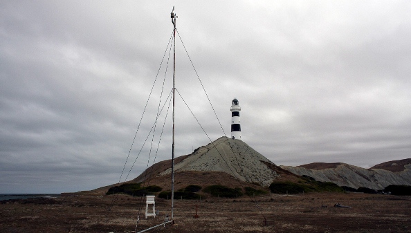
MetService has a team of around 20 staff in its Observations and Engineering section, who are responsible for developing its weather observing network and ensuring that it runs reliably. The team also provides expert technical assistance to Pacific Island National Meteorological Services, to help them establish and maintain effective weather observing programmes. MetService’s New Zealand network currently comprises over 150 automatic weather stations (AWS), 7 weather radar facilities with a further 2 planned, 8 upper-air (balloon launch) sites, and a range of ship- and buoy-based marine observing stations.
MetService maintains a programme of on-going investment in this network to improve its observing capability, leverage new technology and ensure the network’s long-term sustainability. Over the past decade MetService has expanded its AWS network from 62 to 94 sites, and has added a further 73 sites on behalf of commercial clients. It has also introduced 1-minute observation capability at most of its AWS sites, providing forecasters with much greater insight - in real time - into the effects of rapidly changing weather, and refining MetService’s short-range forecasting capability. More recently, MetService has upgraded AWS at airports around the country, implementing sophisticated present weather and state-of-the-sky sensors. This has significantly improved the observation data available to the aviation forecasting team while at the same time reducing the overall cost of the programme.
The on-going expansion of MetService’s weather radar network involves an investment of around $12M over a 5-year period. The installation of new radar systems in Taranaki, Gisborne, Bay of Plenty, Northland and the West Coast will provide much wider coverage of New Zealand’s land area, giving forecasters a more detailed picture of severe weather events. Combined with state-of-the-art software tools for processing radar data, this has also allowed MetService to introduce a new Severe Thunderstorm Forecasting service to all areas with radar coverage. Other areas of MetService investment in weather observing capability include:
-
The development of a sophisticated road weather surveillance network, in collaboration with the New Zealand Transport Agency – this project was recognised as the overall winner at the recent 3M Traffic Safety Innovation Awards 2011
-
Maintaining approximately 30 ship-based AWS as part of the World Meteorological Organization’s Voluntary Observing Ship programme, as well as a network of drifting weather surveillance buoys in the Tasman sea and Southern Ocean – a network that has doubled in size over the past 5 years
-
Implementing multiple communications pathways for mission-critical AWS sites and all radar sites, to improve network reliability
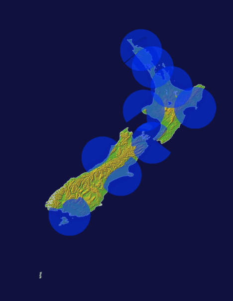 Areas of high-resolution radar coverage following completion of MetService’s radar expansion programme in 2012. Missing parts of circles show areas where radar coverage is blocked by high terrain
Numerical Weather Prediction
MetService has a team of 9 scientists in its Forecasting Research group who are focused on the development of Numerical Weather Prediction models and statistical forecasting techniques. Numerical models play a key role in modern forecasting, providing essential guidance to forecasters and, in some cases, directly meeting the forecast requirements of end users.
Models describe the weather mathematically, using computers to solve the equations that describe how the atmosphere will evolve over time. Global models cover the entire globe and are generally developed and run at large agencies such as the US National Weather Service or the UK Met Office, due to the high cost of personnel and computing equipment required to run them. Limited-area models do the same thing but cover only a specific part of the world, such as New Zealand. This allows the weather to be modelled at higher resolution – in greater detail – using relatively modest computing power. In particular, limited-area models allow the effects of geography on the weather, such as terrain height, coastlines, land surface characteristics, to be more accurately represented.
In a typical forecasting situation, meteorologists use global models to get a picture of how the weather is expected to evolve on a large scale, and then use high-resolution models to help them fill in the detail. There is a limit to how much detail these models can show, but it is possible to go a step further and look at weather effects that are too small to be shown on a model’s 3-D grid. This relies on the combination of model and local observation data using statistical methods.
Unfortunately, there is a catch to all of this, which comes about for two reasons:
(1) the atmosphere is so complex that solving the mathematical forecasting problem requires a lot of approximations, some of them quite crude;
and
(2) it is impossible to accurately describe the current state of the weather everywhere, and so the chaotic nature of the atmosphere will lead to errors developing rapidly in any model prediction, regardless of how good the model itself is.
This means that on any given day, a weather model – even a very good one – can get the forecast badly wrong. The likelihood of this increases as the prediction goes further into the future, which is why a forecast for 10 days ahead is so much less reliable than a forecast for tomorrow.
Meteorologists deal with this by avoiding reliance on any one model – in other words, they don’t put all their eggs in one basket. In fact, they can take advantage of the variations that exist from one model to another to get an idea of the likelihood of different outcomes and how predictable the weather is on the day. If the models are giving the same result, this implies a high degree of confidence in the forecast; on the other hand, wide disagreement between models suggests low confidence.
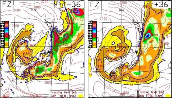
Spot the difference: 6-hour rainfall accumulation (colour coded) from the world’s two leading global models. These would have been available to forecasters 24 hours before the event, which occurred in May 2010. Red or higher colours signal rainfall rates that may lead to severe weather warnings. Although the overall patterns are similar, there are major differences in forecast rainfall over most of the North Island and the east coast of the South Island.
MetService forecasters have access to a diverse range of global models and high-resolution regional models, which are integrated into its day-to-day forecasting process. Global models are accessed through agreements with overseas modelling centres, while MetService’s Forecasting Research team develops and maintains a suite of high-resolution, limited-area models. MetService also has access to some data from NIWA’s NZLAM model – a local implementation of the UK Met Office’s Unified Model – through an informal arrangement with NIWA.
MetService’s in-house model development is based on the Weather Research and Forecasting (WRF) model, an open-source, community model maintained at the US National Center for Atmospheric Research. As well as supporting forecasters with New Zealand model guidance, MetService’s Forecasting Research team plays a key role in its international business, developing specialised model-based forecast products for the energy industry under the Metra brand. These products use a combination of high-resolution local models and proprietary statistical techniques to provide accurate spot forecasts of relevant weather parameters.
MetService’s main areas of interest in modelling R&D are:
Better model physics – this is about improving some of the assumptions that allow models to account for things that happen on a very small scale, but which are critical to getting the larger scale weather right. Particular areas of interest are modelling the earth’s surface more accurately; explicitly modelling convection (i.e., thunderstorms, squall lines, etc.,) with high-resolution models; and improving the way that precipitation processes, such as the formation of raindrops or snowflakes, are accounted for in its models.
Better model resolution – as computing technology advances, MetService is able to run its models at increasingly high resolution for a comparable level of investment in hardware. MetService’s computing strategy is based primarily on clustering of commodity servers using fast networking technology, which is a highly cost-effective approach to high-performance computing. At the moment we are implementing a new model that covers New Zealand and adjacent waters at 4-km resolution.
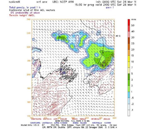
Forecast chart from MetService’s new 4 km resolution New Zealand model, showing wind speed and direction at the surface. Wind barbs point in the direction of flow, with each line in the tail corresponding to 10 knots of speed. Note the complex influence of local geography on the flow, including funnelling through Cook Strait.
Data assimilation – improving the description of current weather at the start of a model run by introducing observation data can dramatically improve the accuracy of model forecasts, and this has been a major factor in the improvement of global models over the past 2 decades. Assimilating data from MetService observing networks into its high resolution models presents a range of technical challenges, but will allow it to improve the accuracy of its models and provide more frequent updates.
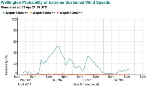
High-resolution ensembles – an ensemble refers to a collection of related model runs that are designed to represent a range of different forecast outcomes. This is a more formal way of using different models to estimate the degree of confidence in a forecast and assess the likelihood of extreme events. MetService forecasters routinely use information from global model ensembles, and the development of high-resolution ensembles will allow a similar approach to forecasting small-scale weather events such as severe thunderstorms.
Statistical methods – MetService has an on-going programme of work to develop advanced statistical forecasting techniques, primarily in support of its work in the energy sector. The focus to date has been on temperature and wind forecasting, and in future this work will be extended to include precipitation forecasting as well as other elements.
End-user applications – while the bulk of MetService modelling R&D effort is aimed at improving its core capabilities, it also develops specialised, model-based forecasting solutions for clients on an as-required basis. A recent example of this is the development of a blowing dust forecast based on a 1.5-km resolution model over Christchurch, to support Civil Defence and other agencies involved in earthquake response. This information was then provided direct to the public on the metservice.com website in the form of easy-to-understand dust graphs.
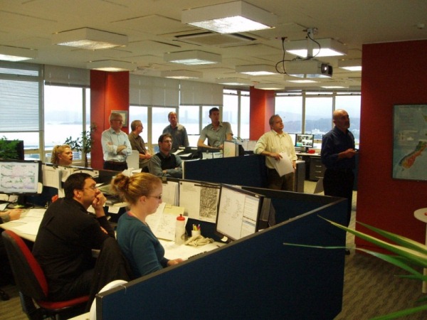
Skilled People While advances in observing systems and modelling will continue to deliver increasingly accurate and detailed information, forecasting will continue to rely on the judgement and interpretation of skilled meteorologists. MetService has a team of around 50 operational meteorologists who are trained to World Meteorological Organization standards.
MetService’s Meteorological Advice and Training group is responsible for the initial training of new recruits, as well as on-going refresher training and skills development for its experienced forecasters. A training programme for new meteorologists is run roughly 2 out of every 3 years. It involves a year of intensive study of theoretical and applied meteorology, culminating in a Post-graduate Diploma from Victoria University of Wellington. Following that, a year of experience in the forecast room prepares the students for accreditation as WMO Meteorologists.
In addition to delivering day-to-day forecasting services, MetService’s team of meteorologists is responsible for a wide range of R&D activities aimed at improving its forecasting capability, through either improved forecasting techniques or a better understanding of New Zealand weather.
An example of a long-term research programme that has delivered direct benefit to New Zealanders is the development of the Severe Thunderstorm Warning service. This work began around 2004 with a detailed investigation of the climatology of New Zealand thunderstorms, with emphasis on the types of convective environments that lead to localised severe weather. As a result, New Zealand-specific techniques to diagnose and forecast severe convective storms have been developed, along with appropriate guidance material based on observation data and MetService’s high-resolution models.
MetService has also implemented state-of-the-art thunderstorm tracking software as part of its weather radar systems, allowing it to rapidly identify, track and forecast the behaviour of severe convective storms. All of this culminated in the successful implementation of the new warning system in July 2009, providing outlooks and watches up to several days in advance for all New Zealand land areas, and up to 2 hours advance warning of severe localised storms for all areas covered by MetService’s weather radar network. The forecasting team is also involved in a wide variety of other research projects, a number of which were presented at Extreme Weather 2011 – the Joint Conference of the New Zealand Meteorological Society and the Australian Meteorological and Oceanographic Society held in Wellington in February 2011. These include:
-
A study of the climatology of cold-season convection in New Zealand, demonstrating that the occurrence of tornados in New Zealand is primarily related to convection along strong cold fronts, rather than the large convective systems (referred to as meso-cyclones or supercells) that produce much of the tornado activity in other parts of the world. MetService is developing a set of forecast parameters and associated tools for tornado forecasting, which will be integrated into its severe thunderstorm forecasting programme.
-
Research into the influence of latent heat associated with melting snowflakes on the development of snowstorms on the South Island – Canterbury in particular. Referred to as “melting-effect storms”, these have specific characteristics that distinguish them from other snow events. MetService has developed a set of techniques to assist with identifying and forecasting these events, which tend to be poorly handled by numerical models.
-
The development of accurate rainfall accumulation analyses based on radar measurements, using rain gauge data to statistically correct for errors in raw radar data. Initial trials have been promising and MetService expects this to lead to the ability to provide reasonably accurate, gridded rainfall estimates in near-real-time.
MetService not only invests considerable financial resources into its forecasting capabilities, funded through its commercial activities; the investment of time and experience from its forecasters – and those supporting them – is significant on a global scale, and is delivering tangible benefits back to the public of New Zealand. [This post was posted on behalf of the writer, Norm Henry - General Manager, National Weather Services, MetService.]
