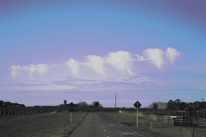
Email received at enquiries@metservice.com Hi there good people from the met service.... The attached photo was one I took the other day while out between jobs. I was intrigued with the formation as I'd never seen anything like this before & it looked like a row of teeth. We live in Blenheim & it's taken from the northern side of Blenheim looking roughly ESE towards the White Bluffs. The forecast was for southerlies arriving later that day. This is one of those curiosity killed the cat type questions - but I've never seen this cloud formation before and keen to find out the reasons and weather that formed this cloud formation. Regards. Al HENDRICKSON.
Response from Bob McDavitt of MetService as part of our "enquiries" team: Hi there Al, and thanks for your photo. I think we are looking here at a layer of air that is showing signs of getting cooler and/or more moist due to changes in the winds aloft. The middle clouds in the background are Altostratus and show that the air is generally stable and flat, as when an anticyclone is moving across the region. Here's my conjecture. The row of teeth started off as row of cumulus clouds -- with a base well above ground level -- not sure how high but I think they are near or above the "freezing level". So that would make them Altocumulus or Ac (Alto means middle , as in the alto voice in a choir). The clouds are forming in a layer where the air is so buoyant that it is able to rise, and there are clear gaps in-between the clouds where there are counterbalancing sinking zones. The Ac clouds can only rise a limited way and then they show signs of leveling out--- this indicates a layer on top of them of warm/dry air. But inside each cloud there is sufficient moisture to allow some to fall out in the form of ice crystals *. As these fall below the base of the cloud they encounter some dry air and evaporate away.... What is left is a "fall streak" or a downward growing protrusion from the cloud called virga. Some of this has been perhaps been caught up in the wind along the base of the clouds and strung out along them, marking the "gum line" -- or this could be just what appears from this viewpoint. * I say ice crystals because they appear so white -- we can get virga from ordinary cumulus clouds that form rain (below the freezing level) but that virga is usually greyish-looking http://www.erh.noaa.gov/iln/Gallery/Clouds/clouds13.html >>>>>>>>>>>>>>>> Thanks again to Al Henrickson for sharing this unusual cloud formation with us all. If you spot some unusual clouds and would like to seek an explanation then send an email to enquiries@metservice.com or go to our contact page. Bob McDavitt
