Written by Georgina Griffiths, Metservice Meteorologist.
The wisdom of the crowd
Written by Georgina Griffiths, Metservice Meteorologist.
The wisdom of the crowd
Satellites are one of a meteorologist’s best tools. Satellite images can tell us where weather systems are and how fast they are moving. They can also often help us distinguish between many things such as thick and thin clouds and high and low clouds, as well as detecting snow, fog, volcanic ash, smoke, thunderstorms, and much more.
Main types of satellite images
The MetService team produces both coastal and recreational marine forecasts. Part of these forecasts includes the state of the sea and the swell. But what is the difference?
Firstly, it is important to understand how a wave is described. Figure one shows the different characteristics of a wave.
New Zealand lies mid-way between the tropics and the Southern Ocean, and our day-to-day weather can arrive from either direction.
Besides the coastal waters, the MetService forecasting team produces marine forecasts for a number of smaller areas where there is a lot of recreational boating activity. These forecasts are routinely issued four times every day; they are monitored continually and updated more frequently if conditions warrant it.
Recreational Forecasts
MetService's forecasting team produces marine forecasts for New Zealand coastal waters. These forecasts are routinely issued four times every day; they are monitored continually and updated more frequently if conditions warrant it.
Forecasts for coastal waters cover the area from the coastline to 60 nautical miles (about 100km) out to sea. The New Zealand coast is divided into 18 areas, as shown in figure 1:
Weather balloons have been released for decades around New Zealand to record data throughout the lower layers of the atmosphere. They have been used to measure everything from the base of low cloud to atmospheric wind and temperature profiles. One of the first people to use weather balloons was French Meteorologist Léon Teisserenc de Bort. He released hundreds of weather balloons from his observatory in Trappes, France. His experiments lead to the discovery of the tropopause and the stratosphere.
 Friday 19 December 2014 sees us gather to farewell John Hickman QSO, Director of the New Zealand Meteorological Service from 1977 to his retirement in 1988. John passed away on 13 December aged 87, after a life of significant contribution to New Zealand's weather knowledge and progress.
Christmas Day in New Zealand can be a hit and miss affair, weather wise. Some years, a High arrives in time for Santa. Christmas Day 2009 was beautifully fine and warm across the country, with Dunedin hitting 32°C, and many other centres approaching 25°C.
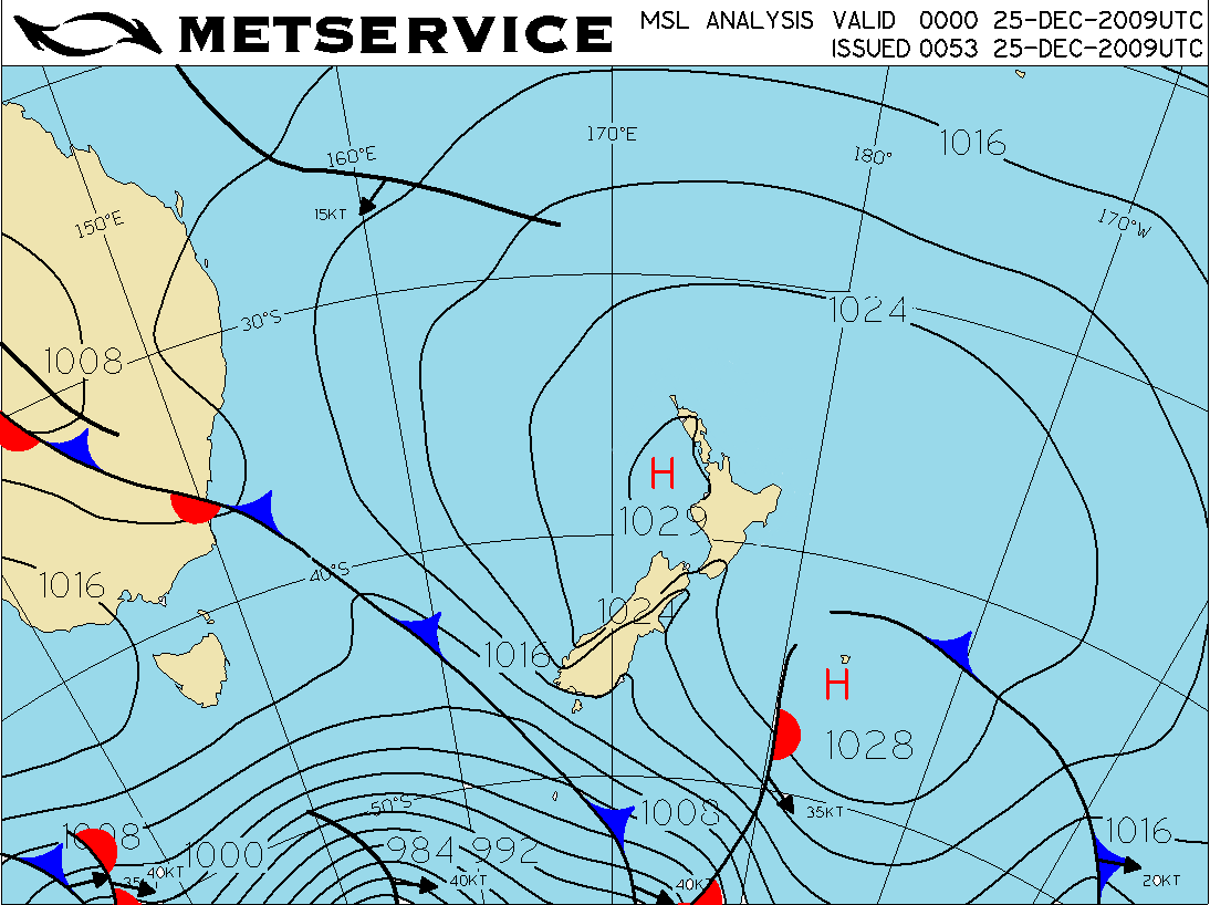 Midday analysis for 25th December 2009.