We all look out the window to see what the weather is up to. In a similar way, MetService meteorologists are always checking to make sure what they have predicted is actually happening.
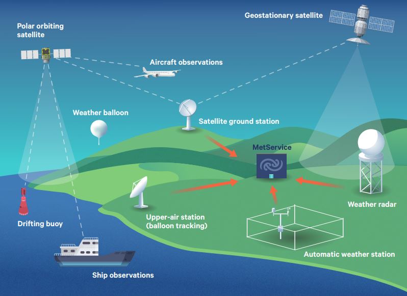
The forecasters may not be examining the skies themselves every few minutes, but they are monitoring a network of instruments across Aotearoa New Zealand, including those sited on our sub-tropical and sub-Antarctic islands, which are constantly feeding back crucial information to the National Forecasting Centre.
Wind direction, wind speed, air temperature, humidity, rainfall, air pressure, cloud, and visibility, etc. – all these observations and data help build a picture of what is going on. But they can’t just be measured from anywhere.
For example, temperature readings taken above or next to a concrete or asphalt surface in a confined space will read several degrees higher than those taken in a grassy location which is better ventilated. While those exaggerated temperatures may be a true reflection of that super-heated spot, they do not represent those of the entire neighbourhood.
Accurate and reliable weather observations that are consistent with the standards of the World Meteorological Organization from around the motu are the bedrock on which good forecasts are based. MetService has a dedicated team who ensure that all our automatic weather stations operate to world standards, and that the observations from our observing network are quality controlled and delivered reliably to the forecasters.
Precise observations do more than tell meteorologists if the weather is unfolding as they had forecast in a certain situation. They are essential as an input to start the computer models which use complex mathematical equations to predict how weather systems will move, form and decay. In other words, the observations are critical to describe the weather now so that models can accurately step forward in time providing our forecasts and warnings. Most importantly the data keeps the computer weather models ‘true’ and in line with what is actually happening with the weather.
Thinking in 3D
We know the Earth’s atmosphere is not two-dimensional, which means observations of temperature, wind and air pressure are not just needed from the surface of the Earth but also right up through the lowest slice of the atmosphere, known as the troposphere, which contains nearly all of our weather.
At Aotearoa New Zealand’s latitude, the troposphere reaches an altitude of about 12km above the surface. Within this layer, large weather balloons carrying radiosonde equipment take regular measurements during their ascent. MetService operates four upper-air sounding stations, at Invercargill, Paraparaumu, and Auckland and one in the Kermadec Islands 1000km northeast of Auckland where these balloons are released once or twice a day.
Pilots flying aircraft at high altitude also pass on observations of wind, temperature, and turbulence to assist meteorologists with their predictions.
Even higher up, weather satellites provide important measurements of moisture and temperature in the atmosphere. MetService meteorologists have access to data from the Japanese geostationary satellite Himawari-8 which effectively provides a photo from space every 10 minutes, so they can see how weather systems develop and move.
On the ground and at sea
MetService has an extensive weather radar network of 10 radars, from Kerikeri in the north to Invercargill in the south. Radars are extremely useful tools for monitoring the movement and intensity of rain, hail, and snow, and are particularly valuable when lives are at risk from severe thunderstorms or for immediate information of rainfall rates in an area with no surface observation. Radars are also vital when tracking a severe thunderstorm cell when the heavy downpours from it could cause flooding.
To complement radar information, forecasters use observations from Transpower’s National Lightning Detection Network to pinpoint where lightning from the severe thunderstorms reaches the ground.
It’s not only the land and the sky which MetService has covered. Ships which travel around our coasts and to and from Aotearoa send through useful observations of the weather conditions out at sea. And a network of drifting buoys in the Tasman Sea provides vital data on developing systems before they reach our shores.
Our observations
Until a few decades ago, surface observations were made manually by people around the country, on farms, at airports, in lighthouses and the like. Some of MetService’s stations have been in operation for more than 100 years – the longer a consistent record the better from a climatological perspective.
Now, most observations come from more than 220 automatic weather stations (AWS) in all corners of Aotearoa New Zealand, which provide data every 60 seconds and are extremely efficient, operating more than 99% of the time. In addition to being used by weather forecasters, data from these stations also feed into the National Climate Database.
As well as operating its own AWS network MetService also partners with other organisations that have networks of stations. MetService also has more than 50 AWS units monitoring road conditions for Waka Kotahi on our state highways and provides Airways Corporation with airport weather conditions at airport control towers across the country.
As well as the observations keeping meteorologists up to date with what they are dealing with, they assess how well the global computer models are performing in the Aotearoa New Zealand region.
We need you!
There’s one other source of weather observations we haven’t covered yet – you! Public feedback and photos via social media and the WOW observations, where members of the public with weather stations can add the information to the WOW map on the MetService website, are extremely helpful.
MetService also calls for snow observers each year and asks for photos and videos from the public to help verify the strength of tornadoes and to share the impacts that severe weather has on our nation.
Keep looking out your window and let MetService know what is happening in your own backyard.