Whether you actively seek the thrill of a good lightning storm or you need to make sure your nervous dog is inside in your protective arms when a thunderstorm hits, MetService has got your back.
MetService has an experienced team of specialist meteorologists who take care of what we call 'mesoscale forecasting' – that is, the forecasting of weather features that are very small in size but can be very intense in nature, e.g. thunderstorms, squalls etc. The relatively small size of these weather features is what makes it a challenge when communicating their potential threat to you and your nervous Labrador.

Thunderstorms, by nature are coy things. They require very specific conditions to ‘kick off’ and when they do it can be within localised areas. By localised we mean that a thunderstorm is small enough that, while you sip your cool lemonade under a sunny sky, 5km down the road a cumulonimbus cloud (thunderstorm cloud) could be throwing 5cm hail on your Aunt Betty’s house.
Below is a bit of an explainer of how we forecast thunderstorms, feel free to skip ahead a couple of paragraphs for the nitty gritty on our Thunderstorm Charts.
For thunderstorms to form they first need an atmosphere that is conducive to vigorous updrafts (i.e. air rising very quickly from the ground). These conditions arise when warm/moist air near the ground is overlaid by cooler/drier air aloft – in meteorologist speak this is called an unstable atmosphere. These conditions can happen in a number of ways. A well-known example happens during summer, when strong heating from the sun creates a much warmer air layer just above the ground, producing an unstable atmosphere. If this layer of warm air is also moist (often moisture is provided from a water source like the sea) then the atmosphere is ‘extra ripe’ for thunderstorms.
So, there is the potential for thunderstorms when an unstable atmosphere is present, but this doesn’t necessarily mean any will form. What we call a trigger is needed to ‘nudge’ off a thunderstorm. These thunderstorms are turning out to be quite hard work to get going!
The trigger to start a thunderstorm can come from several sources. To name a few; fronts which create their own updraft, sea breeze wind convergences where ground level winds from two directions meet and are forced upwards, mountains which force the air up as it tries to pass over them, or features in the upper atmosphere which can create the uplift needed near the ground to generate a thunderstorm. The trigger is often the trickiest part of thunderstorm forecasting as a very subtle change in wind, temperature or frontal strength can be the difference between a crack of lightning or a non-event.

Now you have an idea of what ‘princess and the pea’ type conditions are needed to produce a thunderstorm let’s investigate how MetService relays the risks of a thunderstorm to you at home.
Three different risk charts are produced at MetService, depending on the certainty, severity and how far ahead we expect a thunderstorm to affect an area.
The first and most frequent type issued is called the Thunderstorm Outlook. These charts are issued every day in the morning with an update in the evening (or more frequently if required). As its name suggests the Thunderstorm Outlook chart has the longest forecast range, highlighting areas anywhere in New Zealand with the potential for thunderstorm formation (both moderate and severe) for today and tomorrow. Three risk levels convey the likelihood of thunderstorms forming over the whole area, ranging from low to high.
If you live within a shaded area that happens to be under a moderate or high risk that day, though it is likely that within that whole shaded area a thunderstorm will form, it is possible that you, sitting on your patio, will not see one. This is due to the small and confined ‘mesoscale’ nature of a localised thunderstorm. For example, thundery showers caused by summer sea breezes can be very isolated leading to the ‘sunny day at my place, hail at my Auntie’s 5km down the road’ situation (more on this ‘afternoon convection’ here). However, if we have an active squall that moves across a region you can expect more people to experience thunderstorm conditions.

The second chart our meteorologists produce is called a Severe Thunderstorm Watch. This chart is much like the Thunderstorm Outlook but is only issued when severe thunderstorms are expected anywhere in New Zealand, and it usually has a shorter forecast outlook of 6-12 hours. Again, much like the Thunderstorm Outlook these Thunderstorm Watches are forecasts, created to alert people to the possibility of a severe thunderstorm forming in their area.
So, what makes a thunderstorm severe you may be asking? For MetService, these heavyweights of the thunderstorm world must exhibit at least one of the following criteria; heavy rainfall of 25mm/h or more, hailstones with a diameter of 20mm or more, strong wind gusts of 110km/h or more, or damaging tornadoes.

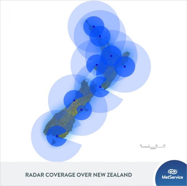
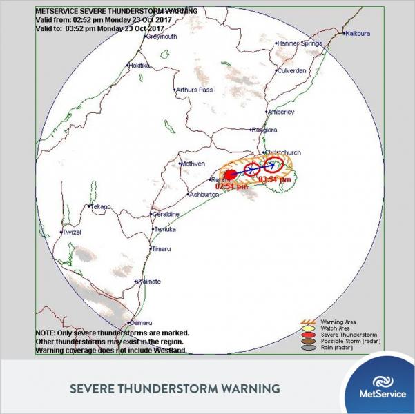
The third and final chart issued for thunderstorms is the Severe Thunderstorm Warning. This chart is different from the two previous charts as it is only issued after a thunderstorm has formed and is deemed severe through careful analysis of volumetric (3-dimensional) radar data. Mesoscale meteorologists need a thunderstorm to be within about 150 kilometres of the radar to fully probe the structure of the storm and therefore categorically define it as severe. For this reason, a Severe Thunderstorm Warning will only be issued inside the deep blue areas in the right-hand image below.

When issued, a Severe Thunderstorm Warning will include the current location of the thunderstorm, a cone for its forecast path and an indication of where the storm will be in 30 and 60 minutes time. Due to how short the forecast time is on these warnings it will usually have a more specific area in which our mesoscale meteorologist has deemed at high risk of seeing a thunderstorm. This means if you are within the Severe Thunderstorm Warning area, keep your Labrador inside or get out the popcorn, you’re likely to see some lightning.
Though the chance of being caught under a severe thunderstorm in New Zealand is low, if you are unlucky enough to experience one unprepared, it can be dangerous, with lightning, large hail, flash flooding, and squally winds among some of the effects of a severe thunderstorm.
What can you do if you have a lead time of an hour or so? Quite a lot in fact. A few simple examples are listed below.
-
Torrential Rain: If you're in a narrow watercourse or working in a stormwater drain, get out of it.
-
Very strong winds: If you're up on the roof, get down, secure loose roofing iron and other potentially dangerous flying objects.
-
Lightning: Go inside, or at least stay away from trees which are out in the open, and consider unplugging electrical appliances.
-
Hail: If you're driving, be ready to slow down or stop, or put the car in the garage.
Thunderstorms are incredible forces of nature, which both fascinate and frighten. Although their effects are often very localised they can be extremely hazardous. Our highly skilled meteorologists use a range of charts to communicate thunderstorm risks and severity through a three-step alert process from Outlook to Watch to Warning. Now that you’ve read this blog, we hope you understand how we alert the public about the chance of thunderstorms from the forecasting bench!