Tropical Cyclone Yasi
Metservice.com Feature "Towns & cities" - Past Weather
"Past Weather" is a feature on our Metservice.com "Towns and Cities" pages and is located on a tab for the relevant location.
This graph shows the elements for Yesterday, the Last 30 Days, as well as Historical Data on a calendar monthly basis.
The data is detailed further upon mouse-over and includes:
- the highest wind gust
- the direction the wind was blowing from
- the highest and lowest air temperatures; and
- rainfall
Here's an example for Auckland Airport for "Yesterday":
The New Zealand Pollen Forecast
Dr David Fountain, Pollen Forecaster (retired).
Weird Taranaki Cloud
Addendum added on 20 Dec 2010 with images from Malcolm Potts
Myth-busting ultraviolet radiation
Written by Wayde Beckman from the Health Sponsorship Council, on 11 November 2010
Who would have thought in November, when temperatures struggle to get over 20 degrees in some New Zealand places, that ultraviolet (UV) radiation levels are already high enough to cause sunburn and put Kiwis at risk of developing melanoma skin cancer?
Verification of Severe Weather Warnings
This blog post is the third in a three-part series discussing verification of MetService forecasts. Here, we present the method used for verifying Severe Weather Warnings, along with some recent examples.
Verification of Maximum and Minimum Temperature in City Forecasts
This blog post is the second in a three-part series discussing verification of MetService forecasts. Here, we present the method used for verifying maximum and minimum temperature in city forecasts, along with some recent examples.
Verification of Rainfall in City Forecasts
This blog post is the first in a three-part series discussing verification of MetService forecasts. Here, we present the method used for verifying rainfall in city forecasts, along with some examples.
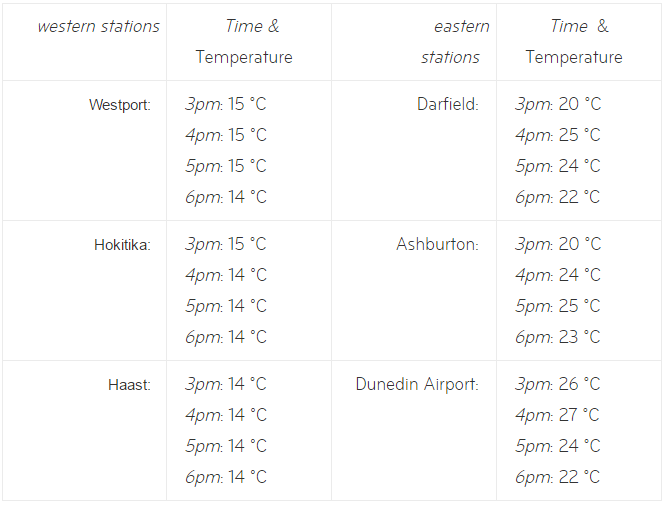
The Foehn Wind
On Saturday 16 October 2010, many parts of New Zealand, especially South Island, experienced Foehn winds. During the approach to summer, eastern parts of both islands will get more warm Foehn winds under suitable conditions. In this blog post I'll describe what the Foehn wind is and explain how it comes about. We'll start by looking at temperature reports from weather stations on Saturday 16 Oct 2010.
Challenges in forecasting severe weather
This article relates to weather experienced in late September 2010