Thunderstorm Event May 2009
Cumulonimbus (CB, thunderstorm) cloud is not a common part of the Wellington cloudscape, and certainly is not in response to diurnal heating as happens in other regions like Waikato and Bay of Plenty. When Wellington gets thunder and lightning it is because of the development of cumulonimbus other than diurnal heating. CB will develop in a cold unstable air mass, and can be triggered by low level convergence usually caused by the wind flow interacting with the land forms. This is why they can occur at any time of the day in Wellington, and it is what happened on Wednesday morning (6 May 2009) when the southern suburbs were rudely awoken by crashing thunder and the sky lit up with spectacular lightning.
It started at 5:45am when a small trough arrived in Cook Strait. The convergence was between the westerlies ahead, and the southerlies behind the trough being squeezed into the harbour entrance. That was the trigger and away it went! Half an hour later it was over and the trough moved away to the northeast.
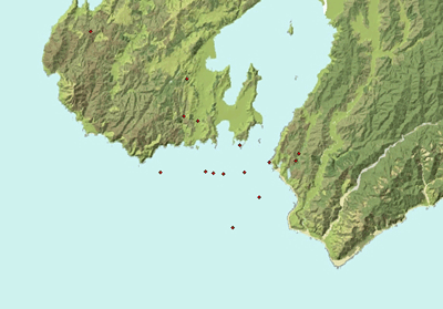
The map is from our Lightning Detection Network and shows the lightning strikes between 5:45 and 6:10am as red dots concentrated over the southern suburbs and south of Island Bay and the harbour entrance.

The radar scan at 6am shows the position of the trough line (by its rain echoes) near Wellington and extending out to the east.
I was in Upper Hutt at this time, just getting out of bed. I heard nothing. While I was waiting for the train at 6:40am I could see the top of a CB to the south. "Hmmm. Interesting. Palliser Bay perhaps?". When I got into the office here, the place was buzzing with excitement, and tales of lightning, hail, and deafening thunder.
This video of the storm was posted on YouTube by Thunder081